<--Google tag--> <--Google tag end-->

Tag: <span>Around Milpitas</span>

Roads & Highways

Find out about road construction plans and delays. Learn what government agencies control these highways. And to relax, enjoy these scenic drives starting in Milpitas, and wandering through our hillsides on backroads.

What is Milpitas known for?
Milpitas is often called the “Crossroads of Silicon Valley” with most of its 13.63 square miles of land situated between two major freeways (I-880 and I-680), State Route 237, and a County expressway.

How far is Milpitas from San Francisco?
The distance between Milpitas and San Francisco is 37 miles. The road distance is 45.9 miles, unless you have a boat to sail between Alviso and San Francisco.

Construction
Governmental Agencies
Scenic Drives

Construction

Calaveras Overpass
The Calaveras Overpass is built to meet the present and growing traffic loads of a progressive city. [They thought!]

Montague Expressway Widening
This project widened Montague Expressway to provide for eight through lanes (three through plus one HOV lane in each direction), with bike use shoulders and improved pedestrian sidewalks from Falcon Drive to Pecten Court (approximately 0.8 miles) including replacement of the double-box culvert crossing of Berryessa Creek with a bridge structure.


VTA Montague Expressway Pedestrian Overcrossing
An incredible project RockViewVideo filmed in Milpitas to chronicle the lift & placement of a huge pedestrian overcrossing above Montague Expressway adjacent to the Milpitas BART Station, July 10-12, 2020.

Transportation Information
As a prominent gateway to the Silicon Valley, the City of Milpitas’ Traffic Engineering section has an integral role in maintaining the City’s economic vitality and creating safe and livable neighborhoods that are pedestrian and multi-modal friendly.

Filing a claim against Caltrans
Did you get a nail in your tire in a highway construction zone? Here’s information and the form for filing a claim.

Governmental Agencies

CalTrans
California Department of Transportations, District 4 (includes Santa Clara County). Lots of local information and pictures about Bay Area Bridges.

Metropolitan Transportation Commission
Regional planning group for our highways here in Silicon Valley and around the Bay.

Scenic Drives

Bay Area Backroads
Go “day tripping” to places near and far. KRON TV offers hundreds of ideas in the South Bay Area and further away.


Calaveras Road to Sunol
Calaveras Road varies from 2 lanes in Milpitas and the 84/680 end in Fremont down to 1 lane in the middle. The south half was recently repaved from Milpitas to the Alameda County line, about 2/3 of the entire ride.

Calaveras – Sierra Rd Loop
Scenic drive in the snowy mountains east of Milpitas and San Jose, California.

California Roadside Rest Areas
Plan your rest stops in rural areas.

Main Street History Tour
Joann Souza narrates a tour of Main Street telling about the historic buildings and sites along the way.

Mt. Hamilton Road
Take this mountain road between Alum Rock and Patterson. Do fill up your thirsty steed because if you decide to continue east down the other side of the mountain, it will be another 70 miles to the next gas station. Very windy and steep. Not for the faint-hearted.


Santa Cruz Mountains Roads
A lovely drive is the one through the redwoods from Woodside, over to the coast, down to Santa Cruz, and back over Rt. 9 through Boulder Creek and Big Basin State Park to Saratoga.

Prepare for a Fire or Earthquake Emergency

I will try to be as specific here to Milpitas residents as possible about how to prepare for emergencies such as wild fires, earthquakes, and sometimes floods. The preparation for all three are the same, but you will get more warning for some than others.

Home Selection

Buy or rent in areas generally far from the wild lands of the east hills. Every section of those hills have had a fire at one time or another, though the scars have long faded as new grass returns. So far fires there have not crossed Piedmont Road, but warnings to prepare for evacuation have been giving to those in neighborhoods on the west side of that road.

Never get a home at the top or bottom of a cliff, even if the view is great. Look at the hills. It is fairly easy to see where there has been running water and sections of the hills have slipped.

Avoid areas that have flooded in the past. That creek may look charming and harmless now, but can become a torrent in heavy rains. The creeks have been fortified, true, but that once in a lifetime flood could still happen. Coyote Creek area can liquefy during a quake.

There is no escaping the fact that our hills were formed by the Calaveras Fault. We will always have earthquakes, but most aren’t bad…yet. The 2003 Working Group for California Earthquake Probability assigned an 11% probability that the Calaveras Fault would produce a magnitude 6.7 or larger earthquake in the next 30 years. See the shake map on our Earthquake page.

Expect that your Milpitas home will be made of wood and stucco, and never brick. Make sure your home has been anchored to its foundation. Do not buy or rent a home that has not been bolted to its foundation!

Day to Day Tips

I know your mom told you to put your clothes back in the closet or laundry hamper each night. Here in Milpitas leave your shoes next to the side of the bed away from a window, and the clothes you just wore nearby, ready to put on should you prefer not to run from your home naked. You can always put the clothes away in the morning. Your bedroom window may break, so don’t place your bed right near it. Assume glass may have gotten in your shoes, so inspect first. Keep a sweatshirt or jacket nearby, even in hot summer weather. Nights can be cool around here.

Keep your medications in box or drawer you could grab fast to take with you. You may need to take extra precautions if you have small children to keep that box or drawer locked. I use a pretty box I found at Michaels.

Keep a flashlight and a battery operated radio in your bedroom, so you can find out what is going on. Should you get trapped, also have a loud whistle. Remember that the call for help is three short bursts, three long bursts, then three short bursts. Wait a little bit to start it up again.

Everything but the clothes could go in a big enough box for your medications.

Know where every family member is at any time of the day or night. You will need to round them up and get them all to safety.

Keep you car’s gas tank always half full minimum, or fully charged each night.

Get everyone over age 12 trained in first aid and emergency preparedness through a youth program such as Boy Scouts or Girl Scouts, Red Cross, local CERT team, or whatever source you can find. Businesses often train teams of employees in these skills.
emergency kit

Make a 72-hour Survival Kit in Advance

You will probably save money and have exactly the stuff you really use if you prepare an Emergency To Go Bag yourself. Many items can be found at local pharmacies, hardware, groceries, and sporting goods stores.

OK, Let’s Prepare the Basics

  • Water – there’s NOTHING more important! You’ll need one gallon of water per person, per day. And you should plan for at least three days. So if there are 5 people in your family, that’s 5 gallons of water per day for three days, equaling 15 gallon of water at the ready!
  • Food. Choose something nonperishable that’s easy to store and carry, like canned goods or freeze-dried food. Remember a can opener!
  • Flashlight – remember extra batteries!
  • Battery-powered or hand-crank radio – NOAA Weather is best.
  • First aid kitRed Cross recommended kit contents
  • Medications – any prescription drugs you or your family need to live, plus over-the-counter items you use like aspirin or allergy meds. Remember an extra pair of glasses if you wear corrective lenses!
  • Multi-purpose tool and duct tape
  • Sanitation and personal hygiene items – Remember a roll of toilet paper and hand sanitizer, feminine products
  • Copies of personal documents – birth certificate, Social Security card, driver’s license, deed/lease to home, passports, insurance policies plus list of medications. Put all of these in a plastic ziplock bag. If you have the means, scan all important documents and store in one of your cloud accounts. Be sure to have ID and Password to your Cloud account written down.
  • Your backup hard drive or laptop
  • Cell phone with chargers, but prepare to deal without them, too.
  • Family and emergency contact information – and keep this not only in your mobile phone, but in a separate book. If you have no ability to charge a dead mobile phone, you’ll need those contacts written down and accessible.
  • Cash – if there are widespread power outages, ATMs don’t work, and stores won’t be able to process debit and credit cards. In a widespread emergency, cash is still king! Jewelry that could be traded in desperation might also be handy.
  • Emergency blanket – light-weight foil blankets are easiest to pack and carry
  • Map(s) of the area. Drop by the AAA store near Staples to get some.
  • Masks for COVID protection.

3 Kits Are Better Than 1

Everyone needs a survival kit. In California, families need to be prepared for wildfire and earthquake emergencies in particular. It’s a good idea to not only pack an emergency kit that you keep at home, but to have one at work, and one in your car.

Do NOT store near your chimney, swimming pool, large trees, or anything else that might fall down in an earthquake or wet supplies in heavy rain. A jam packed garage is also not the best place. In a small place, you may want to disguise your kit as a coffee table or footrest.

Prepare for your Babies and Kids

You know best what your children might really need, so prepare to have duplicates in their To Go bags. Ideas here from the CDC.

You may want to write your name and cell phone number with indelible ink on your child, should you become separated, and they be unable to give a responder that information. Same thing can be done on large pets with spray paint.

Remember to Prepare for Your Pets.

  • WATER!
  • Collar
  • Leash
  • ID/License
  • Food
  • Carrier
  • Bowl

Where to Flee

This is where things get interesting. You really must prepare your escape routes ahead of time, depending on if you might be at home, work or school.

If the East Hills are on fire, go west, toward Mountain View, on 237. But in an earthquake or flood, the Coyote Creek could be flooded or the area around it liquified, and unpassable.

680 north has slides and faults going under it. Know those dips near where Mission Blvd. goes under the freeway and your coffee spills? Land gives way there continuously, and during a big quake, that section will give way.

880 has major overpasses that could give way. It is closest to the Bay so could liquify going north. In the ’85 quake, large sections disappeared up in the Santa Cruz Mountains. Wouldn’t want to be up there in fire season either.

Now Piedmont Road, up against the hills, can get you pretty far south without any bridges. And eventually you could get on 101 South. But Anderson Reservoir dam could give way and flood 101.

As our major source of earthquakes is the Calaveras Fault, you do not want to try to escape an earthquake here by going up in the hills via Calaveras Blvd. Epicenter is often at the Calaveras Reservoir. Fires and landslides, too, are more likely in the hills than down in the valley. That’s a pretty tough drive even in the best of times.

If you are in the middle of town, take Abel St. south and continue south on Oakland Road. Or Milpitas Blvd. north to Warm Springs into Fremont, depending on source of danger.

So, my recommendation: after an earthquake, if your home is safe, plan to stay put in your home or yard, or tent in a City Park until help comes.

Wildlife of Silicon Valley

Many wild animals make their home in the hillsides of Milpitas, and sometimes make their way into back yards. We often see raccoons, gray squirrels, bats, garter snakes, opossums, skunks, and roof rats.

Animals in Your Home or Business

If a wild animal or injured bird is in your yard, here is what to do:
In San Jose, Milpitas, Los Gatos, Cupertino, or Saratoga:
Call: San Jose Animal Care and Services at (408)794-7297. They will transport the animal to WCSV- it is not safe for you to handle or transport.

AAA Creature Catchers
If you need a professional wildlife trapper in San Jose, CA call 408-338-0560. Our range extends from Palo Alto, Mountain View, Sunnyvale, Santa Clara, Cupertino, Saratoga, Los Gatos, Campbell, to Milpitas.

Milpitas Wildlife Control
We are a full-service Milpitas animal trapping and removal company. We specialize in wildlife only.
408-550-6660

Wild animals of Silicon Valley

Observing Wildlife

Alviso Boat Tour
Due to COVID-19 and the current shelter-in-place, we will place the Alviso Boat Tours on-hold until further notice. You can call it a floating classroom for guests who will travel past the salt marshes alongside the Alviso Slough out to where Coyote Creek meets the open waters of San Francisco Bay.

Bay Nature
A new quarterly magazine dedicated to the intelligent and joyful exploration of the natural places of the San Francisco Bay Area and the species that inhabit them.

Coexisting with Our Wild Neighbors
Because our valley provides excellent homes for many species of wildlife, you can find anything from a tiny hummingbird to a large raccoon in our backyards and city parks. Despite the fact that your yard supports wildlife so well, problems occasionally arise with them living so close to people. For example, what would you do with a bird your cat brought to you? Hopefully the suggestions will help prevent potential problems and help us coexist with our wild neighbors.

Coyote Ridge: Treasure of the Santa Clara Valley
Imagine a place of sweeping vistas, singing grass, wildflowers, eagles, falcons, coyotes, but few people. All this within view of the third largest metropolis in America. All this two miles from an interstate highway. The hills on the eastern side of the Santa Clara Valley, known collectively as the Diablo Range, are made up of a rock known as serpentinite.

Don Edwards San Francisco Bay National Wildlife Refuge
Field trip information. Bring your class to one of the nation’s largest urban wildlife refuges for your next field trip. It’s fun, it’s interesting, and your students will remember what they learn at the refuge for years to come. Official site

San Francisco Bay Wildlife Society – Whats Happening
Plan to join the expert guides on a walk through a natural area. Walks every weekend somewhere in the Bay Area.

Sunol Regional Wilderness
Guided science and nature walks in Little Yosemite.

Threatened and Endangered Species of California
From the California Department of Fish and Wildlife. Includes plants and animals.

Urban Wildlife Research Project
To help maintain California’s natural genetic diversity, UWRP’s goal is to map, protect, and enhance the corridors that wildlife use to travel from one region to another. We will partner with other wildlife organizations and government agencies to research and link the wildlife corridors to create a San Francisco Bay Area Wildlife Corridor to ensure the protection of the region’s rich natural heritage.

What is a habitat conservation plan (HCP)?
An HCP is a document that meets federal Endangered Species Act (ESA) requirements and enables local agencies to allow projects and activities to occur in endangered species’ habitats. In exchange, those projects and activities must incorporate HCP-prescribed measures to avoid, minimize, or compensate for adverse effects on natural communities and endangered species.

Wildlife Center of Silicon Valley
A rehabilitation and release facility. We care for injured, sick and orphaned wild animals. 2650-B Senter Road, San Jose, CA 95111, 408-283-0744

Youth Science Institute
A natural science museum serving Santa Clara County in Northern California with three sites, the Youth Science Institute focuses on the delicate interrelationship of people with the natural world.

Wild Animals

Bats
The ones most common in Santa Clara County are the pallid bat, the Yuma bat, the Mexican free-tailed bat, the red bat, the hoary bat, the big brown bat, the silver haired bat, and the canyon bat. The vast majority of bats are insectivores and the rest feed on fruit, mice, and small vertebrates. Because so many bats consume insects, they are very valuable in keeping the insect population down. One bat can catch hundreds of insects in an hour.

Bay Area Puma Project
The Bay Area Puma Project will make a major contribution by gathering and linking habitat and physiology data. The project includes an advisory group of puma researchers and conservationists who will provide input and guidance over the course of the study.

Bobcat
This cute little bobcat came wandering up to our house about a month ago in the morning while my brother and I were watching TV.

California wild pig population far larger than imagined
There are wild pigs in the east hills and in some of the regional parks ringing Silicon Valley.

The Coyote
A pack of coyotes can frequently be heard howling in the east hills. A pack of coyotes is frequently seen and heard in Ben Rodgers Park, where they raid the garbage cans and terrorize pets left outside at night.

Living with California Mountain Lions
Generally, mountain lions are calm, quiet and elusive. But once in awhile, Milpitans living along the east hillside have spotted one in their back yards.


Opossum
If you see an opossum by the side of the road between March and September, check to see if it’s a female with babies in its pouch. When they are four or five inches long, they start leaving the pouch to ride on their mother’s back. When they have reached seven to eight inches body length, they leave the parent to make their own way in the world.

Raccoons
In urban settings, in addition to feeding on backyard fruits, nuts, and vegetables, they scavenge from garbage cans and compost piles. Pet food left outside overnight ranks high as a food resource and then, of course, some people deliberately provide food for raccoons.

San Francisco Garter Snake
Most who appreciate wildlife will agree that the San Francisco Garter Snake is California’s most beautiful snake. The bright orange head, combined with dazzling black and red stripes, is impressive enough, but the pale stripes and belly are washed with the most delicate turquoise. It is just a wonderful serpent.

Squirrels
For a majority of Californians, the tree squirrels in our neighborhoods will be one or more of three species: the native western gray squirrel (Sciurus griseus), the introduced eastern gray squirrel (Sciurus carolinensis), and the introduced eastern fox squirrel (Scirus niger). A good way to tell western gray from the others is to look at the color of the fur on the face.

Tarantula
Tarantulas found in Milpitas are quiet creatures that live in burrows. Their bite is no more dangerous to people than the sting of a bee. Their size and hairiness, however, can give people a fright.

Western Diamondback Rattlesnake
These serpents should be considered armed and dangerous with a well-developed fang and poison delivery system.

Seen other wild animals within the city or in the hills? Contact your web host, Ann Zeise.

See also ~ Birds

Wi-Fi – Wireless Internet Access Points

According to Yelp, these are the best spots for free public wi-fi in Milpitas, CA. Most are restaurants, where you would be expected to order, but the public library is in the list, too.

Free Wi-Fi

Community Coffee
A coffee shop located on the campus of Christ Community Church.
1000 S Park Victoria Dr
(408) 262-8000

Teasociety
Tea Room · Asian Restaurant in Beresford Shopping Center.
55 N Milpitas Blvd
(408) 708-4772

Teaspoon
Boba Shop
201 W Calaveras Blvd
(408) 770-3675

Milpitas Public Library
Borrow books. Use public computers or your own.
160 N Main St
(408) 262-1171

i-Tea
Teas and food. Boba shop.
760 E Calaveras Blvd
(408) 262-2988

Paris Baguette
Cakes, a variety of breads and pastries.
249 W Calaveras Blvd
(408) 263-0404

Peet’s Coffee
Caffes, teas, and chai.
543 E Calaveras Blvd, left of Safeway in Town Center.
(408) 416-0700

BCUTE tea drinks and finger foods
Boba shop.
200 Serra Way, Ste 12 Serra Shopping Center.
(408) 708-5240

How to Register to Vote in Milpitas & Santa Clara County

Register to vote with the Santa Clara County Registrar of Voters.

Who Can Register to Vote?

Have you checked to see if you are already registered to vote? Many have been registered to vote when they got their drivers license. Check here to see if you are already registered. You will need to have your drivers license number available.

Use the California Online Voter Registration System
Paper registration forms are available at the Registrar of Voters Office, U.S. Post Offices, Public Libraries, the Department of Motor Vehicles, and other government offices. Signed & completed forms must be returned in person or by mail to one of the following locations. They cannot be faxed or e-mailed.

Address:  Registrar of Voters, 1555 Berger Drive, Building 2, San Jose, CA 95112 (Click for directions.)
Mailing Address:  Registrar of Voters, P.O. Box 611300, San Jose, CA 95161-1300​​​​​​​​​​​​​

You can register to vote in California if you are:

You can pre-register to vote if you are:

Language Preference

If you wish to continue in a language other than English, please select your language below.

You can permanently vote by mail, too!

For the 2020 General Election, every registered voter has been mailed a ballot, and sometimes a second one. Only return one and destroy the other. While you MAY mail in the ballot for free, some are concerned that the Post Office may not be to handle the deluge of ballots, some may wish to use drop off boxes. These are the locations of the ONLY ballot return boxes in Milpitas. Here is link if you need to drop off your ballot in another city.

Milpitas City Hall – Outside City Clerk Office
455 East Calaveras Boulevard

Milpitas Library
160 North Main Street

Milpitas Unified School District
1331 East Calaveras Boulevard

The following directions were for pre-Covid19 voting for currently registered voters wishing to change to mail-in voting. This would now only apply to those new to the city and county.

  1. Print & complete a Permanent Vote by Mail Application
  2. Request must be received at least 7 days before the election (postmarks not accepted)
  3. Return your request by mail:
    Registrar of Voters
    Vote By Mail Division
    P.O. Box 611750
    San Jose, CA 95161
    … or fax
    Fax: (408) 293-6002

Read more about voting and elections!

Candidates in the Milpitas Primary Election
Voter Information-Milpitas Local Primary Election Results
Voter Information

Proposition and Measure Research Sites

Our ballots have arrived, and while most know the candidates, often there are propositions and measures on the ballot that can be confusing. I will be updating this page with each election to give you places to research these items before you vote.

Milpitas City Measure

Measure F
Measure F is a ¼ cent local sales tax and would cost one penny for every $4 spent. According to city reports, approximately half of Measure F would be paid by visitors to Milpitas. Food purchased as groceries and prescription medication would be exempt from Measure F.

City of Milpitas Public Services Measure. To provide funding to maintain the City’s finances and services, including: police and fire protection, 9-1-1 emergency response, and natural disaster preparation; youth, senior, and recreation services; repairing park equipment and maintaining parks and recreation centers; and attracting and retaining location businesses; shall the measure, establishing a 1/4¢ sales tax, providing approximately $6,500,000 annually for 8 years, requiring independent audits, citizens’ oversight committee, all funds spent locally, be adopted?

The minimum combined 2020 sales tax rate for Milpitas, California is 9% before this new sales tax. This is the total of state, county and city sales tax rates. The California sales tax rate is currently 6%. The County sales tax rate is 3%. Milpitas does not currently collect any sales taxes other than what the county distributes to us. The City does need a new source of income. We have been relying on hotel taxes and property taxes. We turned down having Marijuana Dispensaries, which would have probably more than made up this amount of tax revenue. So if you voted against having dispensaries you should vote FOR this tax. If you voted to allow dispensaries here, you may want to vote NO to force the issue to come up again.

Currently, only the following Santa Clara County cities collect more than 9%

  • Alviso, 9.250%
  • Campbell, 9.250%
  • Los Gatos, 9.125%
  • San Jose, 9.250%

Next door, Fremont, in Alameda County, currently collects 9.250%. All Alameda county cities collect either 9.250% or 9.750%. Source for this info by sorting at the site: California City & County Sales & Use Tax Rates (effective October 1, 2020). Currently Milpitas has a sales tax advantage over its closest neighbors. A 1/4% sales tax might affect consumers shopping for high priced items. Piercy would no longer have an advantage over dealerships in San Jose or Fremont.

Tran, Phan make case for quarter-cent tax measure
Tran and Phan have teamed up to push their case for Measure F, a quarter-cent tax increase measure set to appear before Milpitas residents on this November’s ballot. Should the measure pass, the duo says, it will keep emergency response times low, keep city services open, and establish more COVID-19 testing opportunities for the city.

Pros & Cons

State Propositions

Propositions on 2020 Ballot

League of women Voters of California Ballot Recommendations
Easy Voter Guide
Gives simple explanations of white vote yes or no on each state proposition. From the League of Women Voters.

Propositions are proposed laws presented to the public to vote on. Propositions can make new laws, change existing laws, and sometimes they change California’s Constitution. They can be placed on the ballot by people who collect enough voter signatures or by state lawmakers (the California Legislature). A proposition passes and becomes law
if it receives more than 50 percent YES votes.

Propositions 14 through 24 are “initiatives.” For an initiative:
* A YES vote means that you support the way the proposition would change things.
* A NO vote means that you want to leave things the way they are now.

Proposition 25 is a “referendum,” which asks voters to decide on a law that was already passed. For a referendum:
* A YES vote means that you support the law and want to keep it.
* A NO vote means you do not want the law to go into effect.

LWV Pros & Cons
More detailed arguments for the Propostions. California voters will also be deciding on 12 state propositions that are explained in this Pros & Cons. Four of the propositions were placed on the ballot by the state legislature, seven of them were placed on the ballot by supporters who gathered sufficient signatures and seek to make changes in state laws or
the California Constitution, and one is a referendum that seeks to overturn an existing law, and was also placed on the ballot by supporters who gathered sufficient signatures.


California 2020 props explained in 1-minute videos
Want a quick introduction to the dozen measures on your November ballot? This playlist gives you a 60-second description of each — just play the first one and the rest will automatically play afterward. The Props-in-a-Minute playlist, produced by CalMatters’ reporting team, covers the array of subjects voters will be asked to decide this fall.


California ballot propositions explained | Election 2020
Here’s what voters need to know about the propositions on the California ballot this November — including measures involving affirmative action and consumer privacy and one that would allow parolees to vote. The LA Times explain each measure in a minute. By MAGGIE BEIDELMAN, CODY LONG, YADIRA FLORES, JESSICA Q. CHEN, ALBERT BRAVE TIGER LEE, OCT. 5, 2020

What’s On The Ballot? Here’s A Look At California’s 2020 Propositions
Yes, there will be a dozen different propositions for California voters this year — Prop. 14 through Prop. 25 — on everything from expanding rent control to ending the ban on affirmative action. While we at CapRadio will be reporting on these more up until Nov. 3, we wanted to give you a quick overview now on what each measure covers and what a “yes” or “no” vote will mean. Includes CapRadio reporters talking about propositions. CapRadio is a Sacramento radio station.

Spending on CA2020 Propositions
2020 Ballot Measure Contribution Totals
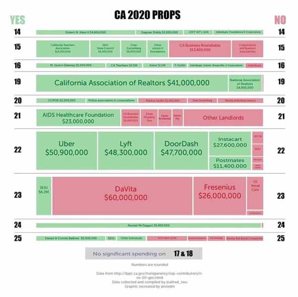
Committees supporting or opposing the following ballot measures have reported total contributions on specified reports, which have been compiled into a total amount of contributions in support or opposition to the ballot measure. From the Secretary of State’s Office. See who is spending big money on the propositions. Are these groups you generally agree with or not?

November 3, 2020, Primary Election Ballot

More Campaign Finance Data

Courage California, a Progressive Voters’ Guide
Group has taken positions (or not) on the Propostions for California on th e2020 ballot.

California Pro-Family Election Center
This is where you can get reliable facts and perspective and advice about how to vote for moral, social, fiscal conservative and constitutional values in California. Bible-based recommendations. Recommends to vote No on all local tax measures.

SF Chronicle Voter Guide
Your guide to the ballot measures, propositions and races that Bay Area voters are deciding. Owned by Hearst family, but they are no longer in full editorial control.

California propositions: What you should know before voting from the Mercury News
Of the 12 measures on this year’s ballot, some may feel very familiar, while others are are all new.

Equality California
The nation’s largest statewide LGBTQ+ civil rights organization, announced endorsements of five 2020 statewide ballot measures and opposition to one measure on Wednesday afternoon. The organization previously endorsed the Schools and Communities First Initiative (Proposition 15) on January 27, 2020. Equality California has endorsed the following November 2020 statewide ballot measures:

Equality California opposes the following November 2020 statewide ballot measure:

  • Proposition 20 – >Criminal Sentencing, Parole and DNA Collection Initiative

For a complete list of Equality California’s 2020 endorsements, please visit eqca.org/elections.

10 Tips to Reduce Your Chances of Becoming a Crime Victim

  • Lock doors and windows when you are not going to be at home. Many home burglaries have occurred by suspects finding an unlocked window or open door to enter through.
  • Lock car doors and do not leave any property in plain view. Valuables left out in the open may tempt thieves. If you must leave belongings in the car, place them in the trunk and out of sight.
  • When walking on the street or to your car from a business, make eye contact with others and be aware of your surroundings. Keeping your head down and not making eye contact with people makes a person look more vulnerable to an assailant.
  • When getting into your car after shopping or doing errands, do not sit in your car for a long period of time. It can give an assailant time to get into the car and rob or assault you.
  • Always look in the back seat of your car before getting in. If someone is in the backseat, exit your car immediately and call the police.
  • If you enter an elevator and feel unsafe because you are alone with someone, exit the elevator – it is better to be safe than sorry.
  • If you are getting harassing phone calls, keep a notebook by the phone and write down dates and times. It helps to keep a log of harassment and the notebook can be given to police as possible evidence in the future.
  • When eating at a restaurant or sitting in a public place, do not leave your purse or purchased items in a vulnerable spot. A purse or bag hanging on the back of a chair can easily be taken by a thief. Keep purchases or bags under the table or in an area where they are not easily accessible. You can put the strap of a bag or purse under the leg of your chair.
  • When needing assistance on the side of the road, and a cell phone is not available, only roll down your window enough to speak to whomever has stopped to help. Ask the person to call police or your roadside assistance provider for you and wait in the car.
  • If you are home alone and a stranger is knocking at the door, speak to them through the door or through a window nearby. If they ask to use the phone, let them know you can call police on their behalf. You do not have to let anyone inside your home to use the phone. This is not rude… it is safe.
  • Watch this video:

See also: Crime Fighting: Ways to fight, prevent and report crimes in Milpitas, CA.

Scam Alerts
GoMilpitas.com provides information to consumers and small businesses about how to recognise, avoid and report ongoing scams.

Utility Scam Alert
Avoid being scammed by fake utility workers, who keep you engaged at your front door while their cohort goes around back and steals from you.

Earthquakes

California earthquake faults and recent earthquakes, and how they affect Milpitas, San Jose, and the San Francisco Bay Area.

Did You Feel It?
This is a U.S. Geological Survey project to collect information about ground shaking following significant earthquakes. Following an earthquake, please tell us what you felt by filling out the questionnaire for the appropriate earthquake. Best site to find information about a very recent earthquake.

Advice
Earthquake Information
Earthquakes Recently
History
Kids Earthquake Links
Maps
Public Seismic Networks

Advice

Are you ready for an earthquake?
The next time disaster strikes, you may not have much time to act. Prepare now for a sudden emergency. Learn how to protect yourself and cope with disaster by planning ahead. From the Red Cross.

Earthquake Engineering
National Information Service for Earthquake Engineering provides this technical site to provide latest research on how to build in a fault zone.

Earthquake Program
The City of Milpitas Building and Safety Department has a program to help you make your house safer. We will provide interested homeowners with a Prescriptive (Cookbook) Plan Set that may be used to strengthen older homes and for obtaining their building permit.

Make your own earthquake preparedness kit
In order to prepare for a major earthquake, SFGate has compiled a list of supplies the American Red Cross recommends you keep on hand.

Protect Yourself During an Earthquake…Drop, Cover, and Hold On!
OFFICIAL RESCUE TEAMS from the U.S. and other countries who have searched for trapped people in collapsed structures around the world, as well as emergency managers, researchers, and school safety advocates, all agree that “Drop, Cover, and Hold On” is the appropriate action to reduce injury and death during earthquakes.

Protecting Your Family From Earthquakes–The Seven Steps to Earthquake Safety (in English, Chinese, Vietnamese, and Korean)
Developed by American Red Cross, Asian Pacific Fund, California Earthquake Authority, Governor?s Office of Emergency Services, New America Media, U.S. Department of Homeland Security Federal Emergency Management Agency, and U.S. Geological Survey.

Putting Down Roots in Earthquake Country
This popular 32-page earthquake science and preparedness handbook has recently been updated. The new version features current scientific understanding of when and where earthquakes will occur in California, and how the ground will shake as a result. Updated maps of earthquakes, faults, and potential shaking are included as well as instructions on how to get information after earthquakes.

Earthquake Information

ABAG Resilience Program
Analysis of Bay Area hazards and how we can prepare for a bad quake.

California’s Earthquake Forum
The home for California earthquake information. A place to ask geologists about western fault information.

Earthquake Outlook for the San Francisco Bay Region 2014–2043
72% probability of one or more M ≥ 6.7 earthquakes from 2014 to 2043 in the San Francisco Bay Region. Earthquakes this large are capable of causing widespread damage; therefore, communities in the region should take simple steps to help reduce injuries, damage, and disruption, as well as accelerate recovery from these earthquakes.

Northern California Earthquake Data Center
The NCEDC is a long-term archive and distribution center for seismological and geodetic data for Northern and Central California.

Recent Earthquakes in California and Nevada
Earthquakes recorded for the last week (168 hours). Times are local (PST or PDT). The most recent earthquakes are at the top of the list. Click through for details.

UC Berkeley Seismological Laboratory
You can even make your own seismogram!

History

1906

The Great 1906 Earthquake And Fire
Original sources and timeline from the Museum of San Francisco.

Story of an Eyewitness
Collier’s, May 5, 1906. Jack London went to the scene of the San Francisco Fire & Earthquake and wrote the following dramatic description of the tragic events he witnessed in the burning city.

1989

1989 Earthquake Reports and Photographs
Fascinating original source material from the Museum of the City of San Francisco, such as 911 reports, photographs, and more.

The October 17, 1989, Loma Prieta, California, Earthquake-Selected Photographs
This publication provides images for use by the interested public, multimedia producers, desktop publishers, and the high-end printing industry.

1998

Mission Peak Landslide of 1998
Report of the engineering firm retained by the City of Fremont to make a preliminary evaluation of the landslide sufficient to guide the city in emergency response and future planning decisions. (Picture)

Kids Earthquake Links

California Has Its Faults
A fault is a fracture along which there is movement. Some faults are actually composed of several fractures called fault branches. Collectively the branches are a fault zone.

Candy Quakes
A lesson plan using a variety of candy which you will quish in a number of ways to demonstrate forces on earth rocks. Clean up is the best part.

Make Your Own Earthquake Crossword Puzzle
Add, edit, delete clues, and customize this crossword. Print copies for an entire class. All in 5 minutes.

FEMA for Kids: Earthquakes
Most of the time, you will notice an earthquake by the gentle shaking of the ground. You may notice hanging plants swaying or objects wobbling on shelves. Sometimes you may hear a low rumbling noise or feel a sharp jolt. The computer simulations include a total of seven earthquake scenarios: three magnitude 6.8 scenarios with different starting locations (epicenters), three magnitude 7.0 scenarios with different starting locations, and one magnitude 7.2 scenario.

Maps

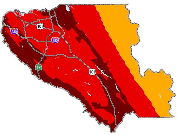
Santa Clara County Earthquake Hazard
Milpitas located in area where freeways make a capital H

ABAG’s Resilience Program – Earthquake Map Santa Clara County
Several active faults present potential hazard to Santa Clara County. On the northwestern boundary, the San Andreas Fault runs through the hills separating the County from Santa Cruz County. In the central county, the Hayward/Rodgers Creek and Central Calaveras dominate the earthquake threat. The Greenville fault dominates in the northeastern portion of the county.

Bay Area Shaking Hazard Maps
The “On Shaky Ground” supplement report lets you select a city (say, Milpitas) and a large quake on a number of Bay Area fault lines. It then shows you a map of how intense various neighborhoods would feel that quake.

San Andreas Fault Facts
California’s sleeping giant, the San Andreas Fault, marks the slippery yet sticky boundary between two of Earth’s tectonic plates. It is responsible for the biggest earthquakes in California, up to at least magnitude 8.1.

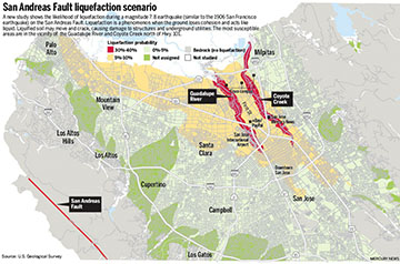
San Andreas Fault Liquefaction Scenario

Santa Clara County Earthquake Hazard
Several active faults present potential hazard to Santa Clara County. On the northwestern boundary, the San Andreas Fault runs through the hills separating the County from Santa Cruz County. In the central county, the Hayward/Rodgers Creek and Central Calaveras dominate the earthquake threat. The Greenville fault dominates in the northeastern portion of the county.

Public Seismic Networks

Public Seismic Network of San Jose
Dedicated to the promotion of awareness and information about earthquakes. It is part of the growing worldwide PSN which connects amateur seismologists, persons interested in earthquakes and seismic activity with information resources; from general history to detailed plans for constructing monitoring instruments and systems.

Guides to Silicon Valley Civic Networks

Before Google Local, small cities relied on such guides to Silicon Valley and else where. The project was called civic networking, and GoMilpitas was one of these very early civic network sites. Many civic networks still exist, each giving a unique view of their local scene in a way Google cannot.
Civic Networking
Civic Networks: Building Community on the Net
By Scott London

About Civic Networking

Zeise’s site is a one-woman operation that’s truly a grass-roots effort. Zeise, who believes a community guide can’t be done properly unless its creator lives in the town it covers, attends Chamber of Commerce meetings and watches city council meetings on television. by Deborah Kong, Mercury News. Read whole article.

The primary aim of this site, GoMilpitas.com, is not to make a significant profit, just enough to pay its bills. The ads pay the bills…just. The whole point of this site is to encourage all of us to work with each other, to connect to make purchases or exchange ideas with each other, and to make Milpitas a truly great small city. No local concern is ever charged for a link on this site, but some businesses may wish to appear on multiple pages, and we are set up to place their ads at a reasonable price.

GoMilpitas.com is under extreme competition from search engines like Google Local and review sites like Yelp, both of which have done their best to kill community networks where locals can determine what the most useful resources are in their towns. This is why I encourage you all to use the links you find on this site to explore resources that interest you in Milpitas. Use this page to look for things in other nearby cities. Support community networks everywhere rather than Google or Yelp. Tell the businesses you connect to that you found their resource on GoMilpitas.com, and drop a plug to advertise on the site so it can stay vibrant.

The Community Network Movement
Realizing that communication and information are increasingly dependent on networked digital information, community activists all over the world ­ often in collaboration with government agencies, non-profits, or businesses ­ are developing community computer network systems.

Central Silicon Valley Civic Networks

Campbell
City site has many features of a good community website.

Cupertino
Mayor Sandra James says the entire community works together to provide the kind of community everyone desires. “Partnerships are what we [in Cupertino] are all about.”

Discover Milpitas
An attempt to rebuild GoMilpitas.com from scratch. Has a lot of things labeled as being in Brea. Looks pretty, but lacks content.

East Palo Alto
For most of its history, East Palo Alto was part of unincorporated San Mateo County. As such, it did not have an official boundary until it incorporated in 1983.

Los Gatos, California, USA
Helpful information for travelers and visitors is available, including maps of the area, pictures of the town, and lists of businesses with contact information. Interesting facts have been collected to provide you with “inside information.” You can even check the weather!

Palo Alto Online
Things to do and places to go in lovely Palo Alto.

San José
City government’s website.

San Jose Chamber of Commerce
The Chamber is the largest business organization serving the Silicon Valley.

San Jose.com
San Jose retains the small town heart of its orchard days when, it has been said, the only chips contemplated were left behind by wandering cattle. Metro’s website.

San Jose Convention & Visitors Bureau
Complete information on attractions, visitor travel and upcoming events in San Jose, California.

San Jose Downtown Association
The heart of Silicon Valley is experiencing a renaissance of culture and commerce. The 11th largest city in the United States has a world-class downtown. Come see for yourself.

Saratoga
A compendium of resources, – including wineries – news, events and weather presented by Dave Delgado.

Santa Clara
Whether you are new to Santa Clara, or a long time resident or business, our Web site is designed to help you learn about services provided by the City, and where you can obtain additional details.

Sunnyvale
Known as the “Heart of Silicon Valley,” Sunnyvale combines the advantages of an attractive suburban setting, a diverse population, metropolitan cultural opportunities, and a dynamic high-technology industrial foundation.

The Penninsula (San Mateo County)

Coastside Live
Half Moon Bay Coastside’s directory including El Granada, Moss Beach, Montara, San Gregorio, La Honda & Pescadero.

Los Altos
Tree lined streets and a small village atmosphere characterize Los Altos which is located in the heart of world famous Silicon Valley. Just 40 miles south of San Francisco, Los Altos is a residential community served by seven small retail areas. The seven square mile city is developed with small businesses, schools, libraries and churches.

Los Altos Hills
The Town of Los Altos Hills is located in the Northern portion of California’s Santa Clara County, situated between San Francisco and San Jose, just Southwest of Stanford University (Palo Alto, California).

Millbrae
The City of Millbrae is located on the Peninsula, 15 miles south of San Francisco. Chamber Site.

Montara
Surfers’ paradise located just north of Half Moon Bay on the coast just south of San Francisco.

Portola Valley
Home to 4400 people living in 1500 households, Portola Valley, California sits in a green and golden valley, astride one of the most dangerous earthquake faults in the world.

San Mateo
City services and events. Official city site.

San Mateo County
Our purpose in County government is to protect and enhance the health, safety, welfare and natural resources of the community.

San Mateo County Convention & Visitors Bureau
Gorgeous natural scenery, attractions, showplace homes and colorful fields and gardens offer a feast for the eyes. All this, plus fine dining, entertainment, shopping and accommodations to fit every budget, make San Mateo County the place for a memorable California meeting or vacation.

South Skyline Association
The purpose of the South Skyline Association is to foster a sense of community spirit, to keep residents and property owners informed of public agency actions or other items of concern in the South Skyline sphere of influence.

South End

Gilroy Visitors Site
Gilroy, California is famous as the Garlic Capital of the World, hosting the annual Gilroy Garlic Festival. Gilroy gives visitors a friendly, small town character with affordable places to stay, great restaurants, wineries, breweries, world-class shopping at Gilroy Premium Outlets factory stores, attractions and recreational opportunities for the whole family.

Hollister
Somethings almost always shaking in Hollister, but this lively community site makes you want to move in anyways. San Benito County.

Morgan Hill
With a population of 33,000, Morgan Hill is located just south of Silicon Valley. Combining great country living with well-known manufacturing and research firms, Morgan Hill prides itself as the “Small town that’s big on business”. Here is the Chamber Site.

South Alameda County

Livermore / Pleasanton & Tri-Valley
eLivermore.com / ePleasanton.org is a community service of Holy Cross Lutheran Church providing information and links to the Livermore and Tri-Valley areas.

Newark
Newark is located in Silicon Valley on the east side of San Francisco Bay. Part of one of the most dynamic urban areas in the world, Newark has maintained a strong and proud spirit rooted in community values.

Sunol.net
Disclamer: This web site is non-commercial and the sole property of Derek Johnson. Nobody pays me to put anything in it. I’ll add what I want, whenever I feel like it (or get around to it, whichever comes last). I disclaim any knowlege of what I am talking about.

Monterey Bay Area

Monterey – Explore
Once a hub of industry, the centerpiece of Monterey–Cannery Row–has been famously revitalized into a complex of world-class restaurants, hip boutiques, and trendy bars.

Pelican Civic Network
A civic network of community groups and people who care about natural and cultural history. Covers from Davenport to Morro Bay.

Santa Cruz City
Located on the sunny side of the beautiful Monterey Bay, 74 miles south of San Francisco. On this site, you will find information about City government, City departments, services, and programs.

Santa Cruz County
Many members of the Santa Cruz area have their own websites as part of “cruzio.com.”

Santa Cruz County
Official county website. Explore our majestic redwood forests and vibrant cityscapes. Taste our fresh cuisine and fine wines. Experience our rich history, acclaimed arts, and year-round events for everyone. In Santa Cruz County, our beaches are just the beginning!

California Community Websites

Berkeley Parents Civic Network
This web site contains thousands of pages of recommendations and advice from the Berkeley Parents Network, a parent-to-parent advice newsletter for the community of parents in the Berkeley, California area. Not limited to just Berkeley.

Davis Community Civic Network
Community resources for this college town in the Sacramento Valley.

East County Live
Civic network that serves Antioch, Pittsburg, Oakley, Brentwood, Byron and Discovery Bay.

Los Banos
Now a Facebook group with regular postings.

Napa Valley
Visit wine country. Covers Calistoga, St.Helena, Oakville/Rutherford, Yountville, Napa and Outlying Areas.

Petaluma Visitors
Locate things to do, and particpate in their many discussion boards. Vote on hot topics!

Point Richmond Online
Neighborhood site to bring a community together.

California Community Networks

There are a good number of free and low cost community networks in California.

KCBXnet formerly SLO Net
SLONET Regional Information Network – San Luis Obispo and northern Santa Barbara counties in California. Site has excellent internet use training course materials available.

Mendocino Community Network
A civic network owned and operated by the Mendocino Unified School District for the purpose of supporting our District’s Internet Node and to benefit our local and global communities. MCN price for residential basic DSL service is now just $14.99 for the first six months. Service now available in the Sacramento, Monterey, Salinas, Chico, Chowchilla, Stockton and LA areas! In the fall DSL is coming to the Kelseyville/Upperlake area.

Napa Net
Offers internet services to residents of Napa, California, including DSL services and virus-free email.

Silicon Valley Public Access Link
A non-profit computer network which makes on-line information accessible to people living in the Silicon Valley regardless of financial status and educational level.

Silicon Valley Unwired
Ten years ago, Milpitas’ free municipal wireless Internet system was a novel idea involving state-of-the-art technology that sought to provide greater web access to the community. A decade later, Milpitas’ citywide Wi-Fi system and its attendant equipment is still in place but now sits mostly unused.

SonicNet
A low-cost ISP as well as a comunity information website for those in Sonoma, California.
Air Travel

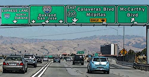
How to get to Milpitas and how to leave it via air travel. Most use SJC out of San Jose, as the closest airport to Milpitas.
SJC Hands

Airlines

Airlines at the Norman Y. Mineta San Jose Airport
Page with the links to each airline, where you can find flight information.

Airplane Manufacturers

RnR Products
Our all composite miniature aircraft have flown the world including the first UAV to cross the Atlantic non-stop! 1120 Wrigley Way, 408-946-4751.

Airports

Norman Y. Mineta San Jose International Airport
Located five miles southwest of Milpitas, San Jose International Airport (SJC) is the closest air service for visitors to travel to and from Milpitas.

Airlines and Flights
This section contains a listing of all airlines servicing San Jose International Airport, their terminal locations, toll-free numbers and Web addresses. Reference our on-line Flight Guide to help you plan your air travel. If you’re checking on an arriving flight, you’ll find a link to Real-Time information with TheTrip.com’s Real-Time Flight Tracker.

To & From SJC
Come and go as you please. This section provides information on maps and directions, parking, meeting passengers, rental cars, taxis, rideshares, public transitdoor-to-door shuttles, hotel shuttles, limousines, scheduled buses, and bicycles and pedestrians.

Passenger Services
Here you’ll find a listing of all the maps of the Airport. These maps will help you locate all the services the Airport has to offer, including: restaurants services and amenities, shops, things to do, public art, and accessible services.

Cargo and Freight
Need information on shipping? This section contains names, toll-free numbers and Web addresses of all cargo carriers servicing San Jose International Airport.

About SJC
There’s more to the Airport than you might have imagined. This section is a compendium of news and information, including employment opportunities, and news releases.

Community and Environment
San Jose International Airport is involved with the community on many levels. This section provides links to the various areas of involvement such as the Noise Abatement, Curfew Monitoring, and Flight Tracking Program with a 10-minute delay.

Oakland International Airport
North of Milpitas about 30 miles. 2nd preferred airport, should you not be able to fly into San Jose.

San Francisco International Airport
The Airport is known as the Gateway to the Pacific for its premier position as a point of departure to many destinations in the Pacific Rim. Find airline flight schedules to and from SFO; ground transportation services; airport terminal guide; and airport parking. Kiss and Fly drop off area.

Planning

Airport Expansion Plans
How might airport expansion affect quality of life in the area. Metro story.

CAAPSO
CAAPSO is a collaboration of interested parties that want to maintain Reid-Hillview (RHV) airport as a vibrant resource for the general aviation community and a benefit to the local community. CAAPSO stands for what we believe in: a Community And Airport Partnership for Safe Operations.

How to stop commercial air hijackings without inconveniencing air travelers
I’ve listed many suggestions below for both increasing security and making the plane a less attractive with minimal passenger air travel inconvenience. Many can be implemented immediately, at virtually no cost. Steve Kirsch

Shuttle Service

Airport Parking Reservations
We’ve done the shopping and negotiated great parking rates for you. We offer you a selection of safe and secure parking operators within 5 minutes of the airport.

Public Transportation to San Jose-Mineta Airport
The Route#60 service schedule has temporarily reduced frequency, running every 20-minutes between the hours of 5:30 AM and end service after 9 PM, 7 days a week. Route #60 will continue to offer free rides from the airport, with a minimal fee to ride into the airport, or free with a transfer pass to the Milpitas Bart Transit Center and the Winchester Transit Center.

Shuttle companies
All over the Bay Area offer airport-to-door service to SJC. Discounts are offered for groups of 2 or more being picked up at the same location. List with phone numbers.

Travelers’ Information

City Hall will now accept Passport Applications
A benefit to residents, the move will also provide additional and much needed revenue. The City of Milpitas will be receive $30 for each processed passport. Applications will be accepted Monday-Thursday, 9a – 3p, and Fridays by appointment. Call the City Clerk’s Office for more information: 586-3001.

Applying For Passports
You may apply for passports at the County of Santa Clara, Office of the Recorder, mornings between 8 a.m. and noon.

Flight Aware
Live current status of any flights between major cities within the United States.

International Travel Information
Travel Warnings are issued when the State Department decides, based on all relevant information, to recommend that Americans avoid air travel to a certain country.

Security Procedures
The Transportation Security Administration (TSA) manages airport security. Visit the TSA website to find up to the minute security procedures and how to best prepare for your next flight.

See also Flying (Recreational Flying)