Tag: <span>Around Milpitas</span>

Temporary Policies and Guidelines Police Department Community Room

Police Logo Star

Novel Coronavirus (COVID-19) Temporary Policies and Guidelines Police Department Community Room

1275 North Milpitas Boulevard, Milpitas, CA 95035

Reservations: 408-586-2402 or vbejines@ci.milpitas.ca.gov

UPDATED: AUGUST 13, 2021

The Milpitas Police Department’s top priority is to ensure the safety of our guests. Please note that any meeting event in the Police Department Community Room is contingent upon current public health orders and City policy.

Vaccination Requirements

The City of Milpitas will not require guests to show proof of vaccination when entering the Police Department Community Room.

Masks and Face Coverings

Effective Thursday, July 29, 2021, the City of Milpitas requires all City employees and visitors to wear face coverings in indoor settings within City buildings, regardless of vaccination status. Masks will not be provided, and guests must bring their own when entering the building.

Room Capacity Limits

The City of Milpitas Police Department is limiting capacity to 35 guests max until further notice.

Food and Beverages

Food and beverages are not permitted, except for water.

Meeting and Time Limits

Only one reservation is permitted in the Police Department Community Room per day. Until further notice, reservations for the Community Room shall be on a first come, first serve basis. Reservations shall not be confirmed more than sixty (60) days in advance, and groups and individual applicants are limited to no more than two (2) reservations per calendar month.

***These guidelines supercede the Community Room additional guidelines dated July 2020. Public health orders are subject to change at any time, and reservations may be cancelled if the public health orders deem non-essential meetings unsafe.

*I have read and undertand the Novel Coronavirus updated policies and guidelines. I further understand that if my group does not abide by these rules, it may result in our meeting being immediately terminated and may result in not being able to use the room for future use.

On official document, applicant would sign and date. See Reservation contact info above.

Other halls in Milpitas.

Chamber holds first in-person mixer at Outback since Covid Shutdown

Networking Mixer at Outback Steakhouse

July 15 @ 5:00 pm – 7:00 pm

We had to show proof of vaccination against COVID, but then we were free to mix and enjoy spare ribs and fries, and drinks of our choices.

Chamber Ambassadors
Chamber Ambassadors
?, Marcella Nichos, Henry Nichols, Tamara Overacker
?, Marcella Nichols, Henry Nichols, Tamara Overacker
Tamara Overacker
Tamara Overacker, Pampered Chef,
T.O. Bookkeeping
Henry Nichols, Oh Henry DJ Services
Jonna and Karen James
Frank J. De Smidt
Frank J. De Smidt
Kelly Yip-Chuan
Kelly Yip-Chuan
Platinum Realty & Finance Group
Evelyn Chua, City Council
Warren Wettenstein and Rob Means
Anand Kuchibhotla. University of Silicon Andhra
Sharon Dyson, St. Elizabeth Knight Sounds
Darissa Acosta, Poppy Bank

Neighborhood Associations

Milpitas neighborhood associations, coalitions, and a lively mail lists to communicate with members about local issues and events.

Associations

Centria Homeowners in Milpitas, CA
Private for neighbors only. This new master plan condominium community offers the latest in fine-living amenities. The “Texas Wrap” construction places the multi-level garage in the center allowing residents to park on the floor on which they live. Community pool, meeting rooms, lush landscaping, walk to the VTA and The Great Mall…all make Centria the perfect location for a carefree lifestyle.

Sunnyhills Board Members

Sunnyhills Neighborhood Association
A volunteer group of homeowners and residents of the Sunnyhills neighborhood who are active in trying to improve our neighborhood, and thus, the city of Milpitas, through positive activities and programs! Facebook page.

The Mission of the Sunnyhills Neighborhood Association in Milpitas is to:
● Provide instruction in civic responsibility and community service;
● Enhance and support education to local residents in art, music, and science;
● Sponsor activities and public performances which enhance the quality of life for all residents in the area;
● Sponsor special events and public gatherings to promote a sense of community well-being and cohesion;
● Sponsor and conduct activities and social gatherings which bridge cultural gaps between different ethnic and cultural segments of the community.
The SNA Board of Directors (2021) include President Allysson McDonald, Secretary Yolie Garcia, Treasurer Rob Means, and Board members BJ Navarro and Demetress Morris.

Coalitions of Neighborhood Associations

United Neighborhoods of Santa Clara County
United Neighborhoods of Santa Clara County (UNSCC) is a coalition of neighborhood associations and homeowner’s associations in Santa Clara County who have come together for the purposes of education, communication and common action. United Neighborhoods of Santa Clara County is a nonprofit (501c3) corporation, and it provides insurance and other benefits to member neighborhoods.

UNSCC is made up of member neighborhood associations and homeowner associations and governed by its Board of Directors. Annual membership dues are $200.00.

Social Networks of Neighborhood Associations

Social Networking Groups for Neighborhood Discussions
Find out about local issues and what is trending in Milpitas, California, in the following social networking groups.

Ethnic Organizations in Milpitas or Nearby

Black, East Indian, Filipino, Hispanic, Native American, Pakistani, Taiwanese, and Vietnamese ethnic organizations in Milpitas or nearby and with a fair number of Milpitas members, which meet to socialize and meet common goals.

Black

National Association for the Advancement of Colored People (NAACP)
The mission of the National Association for the Advancement of Colored People (NAACP) is to secure the political, educational, social, and economic equality of rights in order to eliminate race-based discrimination and ensure the health and well-being of all persons.
1313 N. Milpitas Blvd, #163
408-991-4610

Silicon Valley/Santa Clara County Black Chamber of Commerce
Our mission is to develop and maintain a strong positive alliance between the public and private sector, provide technical assistance through workshops, training programs, and referrals specifically designed to enhance the growth and development of black businesses.
25 N. 14th St, Suite 505, San Jose, CA 95112
408-288-8806

See also: Activism Groups at Milpitas High School

East Indian Ethnic Groups

Bay Area Youth Vaishnav Parivar
BAYVP is an organization with the purpose of bringing together all Vaishnavs of the bay area. Over the past couple of years we have organized various festivals and cultural events including Saptahs, Mahaprabhiji Utsav and Annakut. We also have a yearly picnic in summer for all Vaishnavs and we conduct cultural activities for kids, including weekly Shreemay Vidya Mandir.
25 Corning Ave.
408-586-0006

India Community Center
The ICC was conceived as a place where every generation of the Indian Diaspora could find comfort in various facets of their culture, preserve and practice unique traditions and celebrate festivals and social milestones in a welcoming environment. It was also designed to be a center where people of other cultures can explore and experience Indian traditions and values.
525 Los Coches St.
408-934-1130

Silicon Valley Indian Professionals Association
SIPA is a forum for expatriate Indians in Silicon Valley to contribute towards cooperation between the USA and India in high technology areas.

Filipino Ethnic Group

Filipino American Chamber of Commerce of Silicon Valley
Promotes and assists Filipino American businesses and those wanting to do business with the Philippines. Our goal is to promote economic development in Santa Clara County through international trade, business promotion, business education, entrepreneurship and job creation. Facebook.
2086 Walsh Ave., Ste. B1
Santa Clara CA 95050

408-283-0833

Hispanic Ethnic Group

Hispanic Chamber of Commerce Silicon Valley
The Hispanic Chamber founders sought to maximize Hispanic business and economic development to increase better understanding between Hispanic businesses, corporate America and the community at large.
1887 Monterey Rd, San Jose, CA 95112
408-248-4800

Native Americans


Indian People Organizing for Change (IPOC)
A community-based organization in the San Francisco Bay Area. Its members, including Ohlone tribal members and conservation activists, work together in order to accomplish social and environmental justice within the Bay Area American Indian community. Current projects include the preservation of Bay Area shellmounds, which are the sacred burial sites of the Ohlone Nation, whose homeland is the San Francisco Bay Area.

Pakistani Ethnic Group

Pakistani American Community Center
Our mission is to promote Pakistani culture and serve the community. Facebook page with activities.
372 Turquoise St, Suite # 4
510-995-6096

Taiwanese Ethnic Group

Culture Center of Taipei Economic and Cultural Office in San Francisco (Milpitas), U.S.A.
The Center serves about 710,000 overseas compatriots including 30,000 Taiwanese descents. A central organizing resource for almost all south San Francisco Bay Area Taiwanese organizations, such as Chinese schools, alumni groups, commerce associations, and more. See site for full list.
100 South Milpitas Blvd.
408-747-0394

Vietnamese Ethnic Group

International Children Assistance Network
ICAN is a (501)(c)(3) non-profit organization founded by a group of young Vietnamese professionals in April 2000. Our mission is to help children realize their potential and become the quintessential member of their family and their community. Sobrato Foundation center, off Abbott.
532 Valley Way
408-509-8788 / 408-509-1958

See also ~ Organizations and Charitable Groups in Milpitas
Come enjoy organizations in Milpitas based on your interests and how you want to spend your time helping others. This is the page for adult organizations, charities, and the civic action groups.

FasTrak in Milpitas

FasTrak and COVID-19 – FAQs

What should drivers do? To drive in the FasTrak lane or not?

Cash is not being collected at Bay Area bridges due to COVID-19. Use FasTrak to pay your toll. If you do not have FasTrak, you will receive a bill in the mail for the amount of your toll. It is called a violation, but there are no penalties – just pay the toll by mail with a check or online. If you have FasTrak, this change does not apply to you.

The I-680 Sunol Express Lanes are designated lanes that can be used during heavy traffic to bypass congestion. Express lanes are usually located on the far-left side of select major freeway corridors (described below) and are indicated with white descriptive text on the pavement and electronic signage above the roadway.

How the heck do I drive along SR-237 now with the new FasTrak lane?

How to Order a Transponder and Use the SR 237 Express Lanes

Step 1: Order your transponder
Step 2: Set up your account
Step 3: Mount your transponder. Transponder mounting help.
Step 4: Use the Express lanes

About Express Lanes

An Express Lane is a portion of a High Occupancy Vehicle (HOV) lane, also known as a carpool or diamond lane, that has been converted to a toll lane in order to better manage congestion. VTA monitors its Express Lanes to maintain a minimum speed of 45 mph, based on federal requirement.

Express lanes are marked by large overhead signage, and smaller signs located in the median. The toll amount is posted on a changeable board within the large overhead sign.

VTA currently operates Express Lanes on State Route 237. Learn more about the planning and history of VTA’s Silicon Valley Express Lanes Program and the 237 Express Lanes project page.

How can I enter the FasTrak lane coming from Milpitas?

237 Express Lanes

  • Entering from Calaveras Blvd. westbound on SR237 will be a real pain, just as currently. You will not be able to get into the FasTrak lane until just slightly after Zanker, and it ends just before Lawrence. About half your commute will still be in heavy traffic. To avoid the congestion, you might try…
  • Drive north on Milpitas Blvd. to Dixon Landing Rd, and get on 880 south. Get in the HOV lane there as it swings over and onto 237.
  • Take Tasman. Turn right at Zanker. Enter 237 to right just after 237 overpass. Also good strategy for those heading north on 880 wishing to go west on 237.
  • Going eastbound on SR 237, there are double white lines west of Zanker Road prior to the 237-880 connector. Express lanes traffic wanting to access I-880 South, McCarthy Boulevard, or Calaveras Boulevard will have to exit the lane at Zanker Road.

FAQs about FasTrak

  • Questions about FasTrak? The FasTrak team is here to help! If you can’t find the information you’re looking for below, please contact us. Our Customer Service team wants you to get the most out of your FasTrak account.
  • FasTrak toll tags are also available to order online.

What hours and days is the Express Lanes operational?

  • SR 237 Express Lanes will now operate from 5:00 am – 8:00 pm weekdays, which is consistent with all other Bay Area Express Lane facilities. At all other times, the lane will be available to regular traffic.
  • Weekends everyone may drive in any lane they want to, with any number of people. FasTrak will not be in force.

What if I have a qualified clean air vehicle?

  • Clean air vehicles (CAVs) with valid clean air vehicle decals can travel toll free or at a discounted rate on Bay Area express lanes and state-owned bridges. In order to receive the correct discount, eligible clean air vehicles should use a FasTrak Flex or FasTrak CAV toll tag.
  • On 237, solo drivers in eligible CAVs will receive a 50% discount off the toll if they use a FasTrak CAV toll tag. The FasTrak CAV toll tag is the only transponder that will communicate the discounted toll rate to roadside toll equipment. Clean air vehicles with two or more people can travel toll free as a carpool, but must use a FasTrak Flex or FasTrak CAV toll tag.

Is it charging me each time it beeps?

  • No. It detects when you enter and leave the lane, and so charges you for total time spent in the FasTrak lane.

How do I know how much I am being charged?

  • Express lanes are free for qualifying carpoolers, vanpool, buses, and other toll-exempt vehicles.
  • For solo drivers with a FasTrak toll tag, the prices to drive to specific destinations will be posted on signs above the the express lane. The toll on VTA’s State Route 237 Express Lanes varies dynamically based on congestion. Minimum will be $0.30 and the maximum will be $8.00.
  • The actual toll deducted from your FasTrak deposit will depend on the total distance you travel in the express lane.
  • Tolls for solo drivers increase with congestion, and decrease with light traffic. But here is an example: the average toll paid by solo drivers in the I-680 Express Lane from Pleasanton to Milpitas in the morning commute period for January 2015 was $3.11, an average of $0.22 per mile over the 14 mile express lane length.

How do they know how many people I really have in my car?

  • Video cameras on the sign posts
  • Vigilant police
  • Setting you make on your tag for 1, 2, or 3+ people. Motorcyclists should leave their setting at 3+.

If I accidentally drive in the FasTrak lane without a transponder what happens?

  • You will get a bill based on your license plate registration. The price is listed on the overhead signs.

Bay Area FasTrak Facebook Page
This is the official Facebook page of Bay Area FasTrak. FasTrak is an electronic toll collection (ETC) system that allows you to prepay your tolls at all Bay Area toll bridges, eliminating the need to stop at the toll plaza. The system has three components: a toll tag, which is placed inside your vehicle; an overhead antenna, which reads the toll tag and collects the toll; and video cameras to identify toll evaders.hicles per hour than a cash lane.

As you pass through a toll lane, the toll tag is read, and your tolls are deducted from your prepaid toll balance. When you reach your replenishment threshold, your account is replenished automatically, if you opened your account with a credit card. If you opened your account as a cash/check account, then you are responsible for replenishing your account by making regular payments.

The FasTrak system tracks your usage and account balance. A monthly or quarterly statement itemizing your bridge use and account balance will be sent to you through the mail or emailed to you.

LoopWorks joins race to build 1st Bay Area smart transit

LoopWorks

For Immediate Release: July 2, 2021

Contact: Rob Means, Rob@MilpitasPRT.com

LoopWorks joins race to build 1st Bay Area smart transit

Historically, Bay Area mass transit has grappled with limited connections and timely service. While Caltrain and BART are great, getting to either and then to your final destination is often a challenge.

Attempting to solve these problems are 3 different projects using Personal Rapid Transit (PRT) technology. Each project plots a different approach to success, and each has already secured some of the necessary resources. According to LoopWorks President Matt Kennedy, “After decades of design, development and small-scale projects, PRT technologies are finally being implemented on a larger scale. These are exciting days for a technology that helps solve the connectivity issues that have limited public transportation services.”

The City of San José plans to connect its airport with Diridon train station using Measure A funding authorized by the voters in 2000. The Milpitas project also starts as a small, short-range system, but expects expansion to serve more of the city. The Contra Costa PRT system starts with a vision that spans 4 cities over a 28-mile corridor – Antioch, Pittsburg, Martinez and Concord.

LoopWorks’ Secretary, Rob Means, enthusiastically supports the quick and convenient technology, but is most excited about the data we will get from 3 different approaches. To help himself make sense of what can be learned from the Bay Area trio, he developed the following table of major factors at play in this contest. Listed are resourcesneeded to build a PRT system – and which projects have likely secured them. He believes “These different ways of solving resource needs creates an opportunity for scientific studies comparing the different approaches.”

Resource

Available now, or expected soon, by these projects …

Hardware Design

Milpitas, open source design. Contra Costa Co., proprietary design.San Jose will issue RFP, then choose a design.

Route Selection

Milpitas, dual loop; Contra Costa Co., 28-mile corridor; San Jose will issue RFP, then choose a route.

Funding

San José, 2020 Measure A. Contra Costa Co., private/venture capital. Milpitas expects foundation funding.

Government Support

San Jose and Contra Costa Co. support their projects.

Project Governance

San Jose, government agency. Contra Costa Co., private/for profit firm (Glydways). Milpitas, (LoopWorks)

Projected Public Use

Milpitas, 2028; San Jose, 2028; Contra Costa Co., 2030

“Upon completion of all 3 systems”, Means says, “we will know better which factors are most favorable to success. That will inform and ease a rapid, nation-wide adoption of PRT. Widespread use of PRT is just one of the big changes needed to reverse our Climate Crisis.” Citing the appeal of PRT, he continues, “Just imagine walking a few blocks to board an awaiting RPT cab that takes you to your destination with no hassle and no stops!”

The Contra Costa project offers perhaps the best solution to climate change by going beyond zero to negative carbon emissions by combining PRT’s power-efficiency with photovoltaics embedded into the infrastructure that generate more energy than the PRT system consumes. The project developer, Glydways, is pursuing other projects in the Bay Area.

Learn more about each project:

LoopWorks is a taxable non-profit mutual benefit corporation that is creating a smart transit system to serve the Metro Area around the Milpitas BART Transit Center using convenient and quick Personal Rapid Transit (PRT) technology.

For more information, visit MilpitasPRT.com or email info@MilpitasPRT.com.

Roads & Highways

Find out about road construction plans and delays. Learn what government agencies control these highways. And to relax, enjoy these scenic drives starting in Milpitas, and wandering through our hillsides on backroads.

What is Milpitas known for?
Milpitas is often called the “Crossroads of Silicon Valley” with most of its 13.63 square miles of land situated between two major freeways (I-880 and I-680), State Route 237, and a County expressway.

How far is Milpitas from San Francisco?
The distance between Milpitas and San Francisco is 37 miles. The road distance is 45.9 miles, unless you have a boat to sail between Alviso and San Francisco.

Construction
Governmental Agencies
Scenic Drives

Construction

Calaveras Overpass
The Calaveras Overpass is built to meet the present and growing traffic loads of a progressive city. [They thought!]

Montague Expressway Widening
This project widened Montague Expressway to provide for eight through lanes (three through plus one HOV lane in each direction), with bike use shoulders and improved pedestrian sidewalks from Falcon Drive to Pecten Court (approximately 0.8 miles) including replacement of the double-box culvert crossing of Berryessa Creek with a bridge structure.


VTA Montague Expressway Pedestrian Overcrossing
An incredible project RockViewVideo filmed in Milpitas to chronicle the lift & placement of a huge pedestrian overcrossing above Montague Expressway adjacent to the Milpitas BART Station, July 10-12, 2020.

Transportation Information
As a prominent gateway to the Silicon Valley, the City of Milpitas’ Traffic Engineering section has an integral role in maintaining the City’s economic vitality and creating safe and livable neighborhoods that are pedestrian and multi-modal friendly.

Filing a claim against Caltrans
Did you get a nail in your tire in a highway construction zone? Here’s information and the form for filing a claim.

Governmental Agencies

CalTrans
California Department of Transportations, District 4 (includes Santa Clara County). Lots of local information and pictures about Bay Area Bridges.

Metropolitan Transportation Commission
Regional planning group for our highways here in Silicon Valley and around the Bay.

Scenic Drives

Bay Area Backroads
Go “day tripping” to places near and far. KRON TV offers hundreds of ideas in the South Bay Area and further away.


Calaveras Road to Sunol
Calaveras Road varies from 2 lanes in Milpitas and the 84/680 end in Fremont down to 1 lane in the middle. The south half was recently repaved from Milpitas to the Alameda County line, about 2/3 of the entire ride.

Calaveras – Sierra Rd Loop
Scenic drive in the snowy mountains east of Milpitas and San Jose, California.

California Roadside Rest Areas
Plan your rest stops in rural areas.

Main Street History Tour
Joann Souza narrates a tour of Main Street telling about the historic buildings and sites along the way.

Mt. Hamilton Road
Take this mountain road between Alum Rock and Patterson. Do fill up your thirsty steed because if you decide to continue east down the other side of the mountain, it will be another 70 miles to the next gas station. Very windy and steep. Not for the faint-hearted.


Santa Cruz Mountains Roads
A lovely drive is the one through the redwoods from Woodside, over to the coast, down to Santa Cruz, and back over Rt. 9 through Boulder Creek and Big Basin State Park to Saratoga.

Korean BBQ Dining in Milpitas

Dining and Food ~ Restaurants in Milpitas ~ Asian Pacific Dining

Korean BBQ restaurants offer in-table grills for cooking your meats to the doneness you prefer, and dip in a tasty sauce.

Bamboo Korean BBQ House
Order online. Menu. This is a hidden gem when it comes to Korean restaurants.
Yelp
260 S Abel St
408-263-6705

Gen Korean BBQ House
Local chain offering Korean BBQ grilled tableside & ban-chan in a trendy, modern setting.
190 Barber Ln.
408-955-0228

Hansang Tofu
We offer high quality, authentic Korean cuisine that includes Kalbi, Bulgogi, K-Chicken, Army Stews, and much more! We strive to provide delicious meals along with great service in a clean, upscale environment.
57 N Milpitas Blvd.
408-770-2107

Jang Su Jang
They know how to consistently make great food. The place is a too noisy, but the decor is the best for a Korean restaurant. That’s why I take clients there when they want Korean food.
Yelp
269 W Calaveras Blvd
408-262-3434

Koong’s
Chinese, Korean, Noodles. Yelp. Koong’s serves Korean-Chinese dishes. If you’ve been to San Tung in San Francisco, it’s pretty similar. Possibly even better cause there’s no wait.
103 N Milpitas Blvd.
408-946-8020

My No.1 Sushi & Tofu
Yelp reviews. Spicy Korean favorites & a free ice cream chaser served in a casual outlet with simple decor.
1747 N Milpitas Blvd.
408-946-5100

So Gong Dong Tofu House
Yelp reviews. Been craving Korean food lately, so decided to give this place a try. The food here is very good and so is the service.
231 W Calaveras Blvd
408-262-5454

Return to Asian-Pacific Dining in Milpitas

Prepare for a Fire or Earthquake Emergency

I will try to be as specific here to Milpitas residents as possible about how to prepare for emergencies such as wild fires, earthquakes, and sometimes floods. The preparation for all three are the same, but you will get more warning for some than others.

Home Selection

Buy or rent in areas generally far from the wild lands of the east hills. Every section of those hills have had a fire at one time or another, though the scars have long faded as new grass returns. So far fires there have not crossed Piedmont Road, but warnings to prepare for evacuation have been giving to those in neighborhoods on the west side of that road.

Never get a home at the top or bottom of a cliff, even if the view is great. Look at the hills. It is fairly easy to see where there has been running water and sections of the hills have slipped.

Avoid areas that have flooded in the past. That creek may look charming and harmless now, but can become a torrent in heavy rains. The creeks have been fortified, true, but that once in a lifetime flood could still happen. Coyote Creek area can liquefy during a quake.

There is no escaping the fact that our hills were formed by the Calaveras Fault. We will always have earthquakes, but most aren’t bad…yet. The 2003 Working Group for California Earthquake Probability assigned an 11% probability that the Calaveras Fault would produce a magnitude 6.7 or larger earthquake in the next 30 years. See the shake map on our Earthquake page.

Expect that your Milpitas home will be made of wood and stucco, and never brick. Make sure your home has been anchored to its foundation. Do not buy or rent a home that has not been bolted to its foundation!

Day to Day Tips

I know your mom told you to put your clothes back in the closet or laundry hamper each night. Here in Milpitas leave your shoes next to the side of the bed away from a window, and the clothes you just wore nearby, ready to put on should you prefer not to run from your home naked. You can always put the clothes away in the morning. Your bedroom window may break, so don’t place your bed right near it. Assume glass may have gotten in your shoes, so inspect first. Keep a sweatshirt or jacket nearby, even in hot summer weather. Nights can be cool around here.

Keep your medications in box or drawer you could grab fast to take with you. You may need to take extra precautions if you have small children to keep that box or drawer locked. I use a pretty box I found at Michaels.

Keep a flashlight and a battery operated radio in your bedroom, so you can find out what is going on. Should you get trapped, also have a loud whistle. Remember that the call for help is three short bursts, three long bursts, then three short bursts. Wait a little bit to start it up again.

Everything but the clothes could go in a big enough box for your medications.

Know where every family member is at any time of the day or night. You will need to round them up and get them all to safety.

Keep you car’s gas tank always half full minimum, or fully charged each night.

Get everyone over age 12 trained in first aid and emergency preparedness through a youth program such as Boy Scouts or Girl Scouts, Red Cross, local CERT team, or whatever source you can find. Businesses often train teams of employees in these skills.
emergency kit

Make a 72-hour Survival Kit in Advance

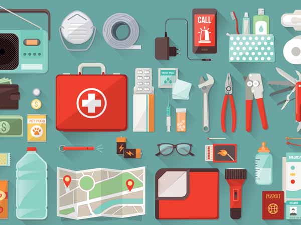
You will probably save money and have exactly the stuff you really use if you prepare an Emergency To Go Bag yourself. Many items can be found at local pharmacies, hardware, groceries, and sporting goods stores.

OK, Let’s Prepare the Basics

  • Water – there’s NOTHING more important! You’ll need one gallon of water per person, per day. And you should plan for at least three days. So if there are 5 people in your family, that’s 5 gallons of water per day for three days, equaling 15 gallon of water at the ready!
  • Food. Choose something nonperishable that’s easy to store and carry, like canned goods or freeze-dried food. Remember a can opener!
  • Flashlight – remember extra batteries!
  • Battery-powered or hand-crank radio – NOAA Weather is best.
  • First aid kitRed Cross recommended kit contents
  • Medications – any prescription drugs you or your family need to live, plus over-the-counter items you use like aspirin or allergy meds. Remember an extra pair of glasses if you wear corrective lenses!
  • Multi-purpose tool and duct tape
  • Sanitation and personal hygiene items – Remember a roll of toilet paper and hand sanitizer, feminine products
  • Copies of personal documents – birth certificate, Social Security card, driver’s license, deed/lease to home, passports, insurance policies plus list of medications. Put all of these in a plastic ziplock bag. If you have the means, scan all important documents and store in one of your cloud accounts. Be sure to have ID and Password to your Cloud account written down.
  • Your backup hard drive or laptop
  • Cell phone with chargers, but prepare to deal without them, too.
  • Family and emergency contact information – and keep this not only in your mobile phone, but in a separate book. If you have no ability to charge a dead mobile phone, you’ll need those contacts written down and accessible.
  • Cash – if there are widespread power outages, ATMs don’t work, and stores won’t be able to process debit and credit cards. In a widespread emergency, cash is still king! Jewelry that could be traded in desperation might also be handy.
  • Emergency blanket – light-weight foil blankets are easiest to pack and carry
  • Map(s) of the area. Drop by the AAA store near Staples to get some.
  • Masks for COVID protection.

3 Kits Are Better Than 1

Everyone needs a survival kit. In California, families need to be prepared for wildfire and earthquake emergencies in particular. It’s a good idea to not only pack an emergency kit that you keep at home, but to have one at work, and one in your car.

Do NOT store near your chimney, swimming pool, large trees, or anything else that might fall down in an earthquake or wet supplies in heavy rain. A jam packed garage is also not the best place. In a small place, you may want to disguise your kit as a coffee table or footrest.

Prepare for your Babies and Kids

You know best what your children might really need, so prepare to have duplicates in their To Go bags. Ideas here from the CDC.

You may want to write your name and cell phone number with indelible ink on your child, should you become separated, and they be unable to give a responder that information. Same thing can be done on large pets with spray paint.

Remember to Prepare for Your Pets.

  • WATER!
  • Collar
  • Leash
  • ID/License
  • Food
  • Carrier
  • Bowl

Where to Flee

This is where things get interesting. You really must prepare your escape routes ahead of time, depending on if you might be at home, work or school.

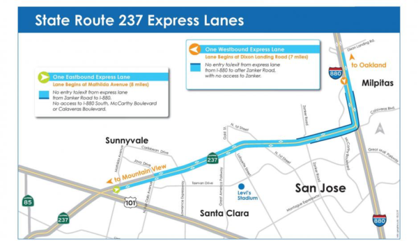
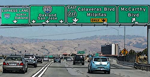
If the East Hills are on fire, go west, toward Mountain View, on 237. But in an earthquake or flood, the Coyote Creek could be flooded or the area around it liquified, and unpassable.

680 north has slides and faults going under it. Know those dips near where Mission Blvd. goes under the freeway and your coffee spills? Land gives way there continuously, and during a big quake, that section will give way.

880 has major overpasses that could give way. It is closest to the Bay so could liquify going north. In the ’85 quake, large sections disappeared up in the Santa Cruz Mountains. Wouldn’t want to be up there in fire season either.

Now Piedmont Road, up against the hills, can get you pretty far south without any bridges. And eventually you could get on 101 South. But Anderson Reservoir dam could give way and flood 101.

As our major source of earthquakes is the Calaveras Fault, you do not want to try to escape an earthquake here by going up in the hills via Calaveras Blvd. Epicenter is often at the Calaveras Reservoir. Fires and landslides, too, are more likely in the hills than down in the valley. That’s a pretty tough drive even in the best of times.

If you are in the middle of town, take Abel St. south and continue south on Oakland Road. Or Milpitas Blvd. north to Warm Springs into Fremont, depending on source of danger.

So, my recommendation: after an earthquake, if your home is safe, plan to stay put in your home or yard, or tent in a City Park until help comes.