Tag: <span>Visit</span>

Indigenous People (Ohlone Indians) of Silicon Valley

History of the Ohlone Indians, the indigenous people who inhabited the south San Francisco Bay region of California.

Bloody Island Massacre
To this day, the US Army, State of California, or County of Lake, have made no attempt to apologize for nearly annihilating the innocent Pomo people of Bodanapotti.

California Powwow Calendar
Check here for powwows of indigenous people being held in California.

California Cultures: Native Americans
At the time of Spanish colonization in the late 1700s, California was home to more than 300,000 indigenous people in more than 200 tribes. Their centuries-old way of life was brought to an end relatively quickly: native Californians soon established regular trading relationships with the Spanish, increasing coastal groups’ power and prestige, giving them greater leverage in dealings with inland groups.

California Indian Heritage Center
After a long search for an appropriate site, the California Indian Heritage Center Task Force and California State Parks secured a new location along the Sacramento River in West Sacramento.

California Indian Pre-Contact Tribal Territories
Nicely labeled map graphic showing where each California Indian tribe lived in early California. Perfect for illustrating a 4th grade report.

Chitactac-Adams Heritage County Park
The park features the beautiful Uvas Creek and a wealth of cultural artifacts including bedrock mortars and petroglyphs left by the Ohlone Indians. Visit the park.

Coyote Hills Knap-in and the Gathering of Ohlone Peoples
At the Coyote Hills Regional Park in Fremont, California. Photos.

Federally Recognized California Tribes
The BIA only give the tribe’s legal name — often that of its little rancheria — so I added the tribe or tribes included for each. I’ve grouped the rancherias by tribe, and arranged the groups roughly from north to south.

First Californians
What happened to the first Californians? Before 1769, over 300,000 Native Californians lived in the state. This population was made up of over 100 tribes that practiced diverse cultural and linguistic traditions. In 1870, 22 years after the discovery of gold in California, less than 30,000 were left.

A History of American Indians in California
Unlike the present population of California, the Indians lived well within the capacity of their environment. They developed religious systems and social norms, and they traded with their neighbors for goods or services not available in their own communities. National Park Service.

The Indigenous Holocaust in Big Sur – Life and Death at the Carmel Mission
One has to wonder – if traditional life in the pre-contact Indian villages on the Monterey Peninsula was so great, and the game so plentiful, and their spiritual life so satisfying, what in the world possessed these contented Indians to voluntarily, sometimes it seems, even eagerly, enter a Catholic mission in the first place?


In the Land of My Ancestors – Kanyon “Coyote Woman” Sayers-Roods and POST
The film is about the life and work of the mother of Kanyon “Coyote Woman” Sayers-RoodsAnne Marie Sayers, and her work stewarding Indian Canyon, the only Federally recognized Indigenous land in the Bay Area, located just south of Hollister. Kanyon will share more about her story, the film, and other issues related to Indigenous communities of the Bay Area.

Indian Canyon
The free, non commercial, Indian Created and Managed information site on Costanoan/Ohlone and California indigenous people.


Indigenous History in the Bay Area, Part 1: Overview – Mark Hylkema and POST
Before the Spanish arrived here and before California became a part of the United States, the Bay Area was one of the most densely populated and linguistically diverse areas in North America. This session provides a broad overview of historic Indigenous communities in our area based on what we know of archaeological studies and oral histories. Participants will learn a basic framework for understanding the complex and varied native communities of the Peninsula and the South Bay.
Session 2 and Session 3.

Indigenous Populations in the Bay Area
It is critical to recognize the Bay Area’s Indigenous populations, past and present. Despite the atrocities of colonization and genocide, Native communities persist today and are active in efforts to preserve and revive the culture. According to the U.S. Census, the Indigenous population in the Bay Area is 18,500 strong and is projected to grow over the next few decades.

Ishi Collection
Ishi, born probably about 1860, spent most of his life in hiding with his family, avoiding the assaults of white settlers moving into Yahi territory. Finally, on 29 August 1911, Ishi walked into the nearby town of Oroville, CA. Apparently, all the members of his family, along with the rest of the Yahi, had perished

Linda Yamane’s Apprenticeship Blog
Ohlone feathered baskets involve a labor-intensive three-rod coiling technique. In addition to the delicate work of incorporating fine mallard duck feathers throughout the outer basket wall, the baskets are adorned with quail topknot feathers and abalone shell dangles.

Living on Ohlone Land
The agreement with Planting Justice is a first step in a far more ambitious effort to repatriate East Bay land to Ohlone people. The Sogorea Te Land Trust intends to acquire dozens or even hundreds of parcels in a patchwork throughout the East Bay, partly using funds generated by the “Shummi Land Tax” — a voluntary way for non-indigenous Bay Area residents to acknowledge the theft of Ohlone land and work toward its healing.

Muwekma Ohlone Tribe of the San Francisco Bay Area
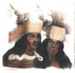
Over ten thousand years ago, before the waters of the Pacific Ocean passed through the gap now spanned by the Golden Gate Bridge and filled the interior valley-basins, the ancestors of the present-day Muwekma Ohlone along with the neighboring tribal groups had established their homes within this changing landscape.

Ohlone Costanoan Esselen Nation
Presently Ohlone Costanoan Esselen Nation represents over 600 enrolled tribal members of both Esselen and Carmeleno descent from at least 19 villages from a contiguous region surrounding Monterey Bay.

The Ohlone People
Ancestors of the Ohlone people wandered into this land of great abundance several thousand years ago.

An Overview of Ohlone Culture
In the 16th century, (prior to the arrival of the Spaniards), over 10,000 Indians lived in the central California coastal areas between Big Sur and the Golden Gate of San Francisco Bay. This group of Indians consisted of approximately forty different tribelets ranging in size from 100-250 members, and was scattered throughout the various ecological regions of the greater Bay Area.

Early California: pre-1769–1840s: Native California
Beginning in the 1840s, leaders and politicians used the phrase, “Manifest Destiny” to justify American expansionism and make it seem preordained. Instead of waiting for the organic, though inevitable expansion of the U.S. population to the West, the federal government took actions to both accelerate and control westward expansion. The goal of “settling” the country from ocean to ocean had a profound impact on the Native Americans, who had no place in this vision of the nation’s destiny.

Shapes and Uses of California Indian Basketry
A basket was worked, and formed of grasses, twigs and fibers into a piece of artistic design–sometimes only to be admired for its artistry, but usually created to serve a further purpose. Baskets were made to serve all the container needs of the early California peoples who had no pottery.

Short Overview of California Indian History
Few contemporary Americans know of the widespread armed revolts precipitated by Mission Indians against colonial authorities. By Professor Edward D. Castillo

Song for the Ohlone
by Martha Robrahn: We have walked these hills and valleys long before your time, When the waters ran clear, the forests stood tall, The earth gave us all we could ever need, And we lived our lives in dignity.

Those Who Came Before
Long before the Stanfords built their farm, the Muwekma-Ohlone called this land their own. Now the University is striving to preserve 5,000 years of history.

Shopping Centers in Milpitas

Shopping Centers in Milpitas offer centers of cultural delight! Poking around our shops is like taking a world tour at your own pace for the food and household items you need, while getting style from the world over.

Abel Plaza
N. Abel Street at E. Calaveras Blvd.
Major merchants: Swagat Indian Cuisine, Ta Restaurant

Beresford Square
Stores in this mall sorted by type, including phone numbers.
N. Milpitas Blvd. at W. Calaveras Blvd.
Major merchants: Marina Grocery, CVS,

Calaveras Plaza
W. Calaveras Blvd. near Abel St.
Major merchants: Grocery Outlet, FedEx

Fiesta Shopping Center
Dempsey Rd.
Major merchants: 

Foothill Square
Jacklin Road near Escuela Parkway
Major merchants: Smart & Final, Dollar Store

Great Mall of the Bay Area
I-680 and I-880. Take Great Mall exit off of I-880.
Major merchants: Marshall’s, Off 5th Ave., Century 20, Old Navy, Burlington Coat Factory, Dave & Busters. How to get to the Great Mall from San Francisco on public transportation. Catch the CalTrain at 700 4th St. and take to Mt. View. Transfer to Light Rail line: “Tasman East/Capitol Light Rail” going east and get off at the Great Mall stop. Map to Great Mall Parkway at Interstate 880 for drivers.

Shopping categories at the Great Mall

McCarthy Ranch Marketplace
McCarthy Blvd.
Major merchants: Wal-Mart, Michaels, Ross

Milpitas Mall Shopping Center
Landess Ave. between I-680 and S. Park Victoria
Major merchants: Seafood City, Seasons Shopping Mall

Milpitas Center Shops & Restaurants
W. Calaveras Blvd. next to Calaveras Plaza
Major merchants: Mil’s Diner, O’Reilly’s, and Goodwill.

Milpitas Square
Barber Lane near McCarthy Ranch Shopping Center
Major merchants: Ranch 99 Market, Mayflower restaurant, New Tung Kee Noodle House

Milpitas Town Center
E. Calaveras Blvd. and Hillview
Major merchants: Safeway, Staples, 24 Hour Fitness, Giorgio’s Italian Restaurant, BevMo

Park Victoria Shopping Center
Park Victoria Dr. near East Calaveras Blvd.
Major merchants: Ocean Market

Parktown Plaza
Park Victoria Dr. near Landess Ave.
Major merchants: Luckys, Rite Aid Pharmacy

Seasons MarketPlace
Your First One-Stop Filipino Lifestyle Center.
1535 Landess Ave.,
408-586-9800
Major merchants: Seafood City, Goldilocks, Max’s of Manila

Serra Center
E. Calaveras Blvd. near Abbott Ave.
Major merchants: Chili’s, Big Lots

Sunnyhills and City Square
North Milpitas Blvd. near Dixon Landing Rd.
Major merchants: Lion Food Center

Ulferts Center
West Milpitas. Just south of Milpitas Square. Many Asian restaurants and services.
648 – 794 Barber Lane, Milpitas, CA, 95035

Victorian Square Shopping Center
E. Calaveras Blvd. near Park Victoria Dr.
Major merchants: 

Calendars of Events In and Near Milpitas

Are you looking for something fun or entertaining or enlightening to do this month? Here are calendars of events from South Bay organizations that list their activities online.

Milpitas Calendars

***GoMilpitas Event List***
View numerous events posted on GoMilpitas. Do you have an event you’d like to list? Either email or call our webmaster, Ann Zeise, or join the site and enter your own event.

Big Dog Vineyards
Select Events by month. Calendar of Wine Tasting – usually first weekend in warm-weather months – and concerts.

Chamber of Commerce
Parties, mixers, forums, luncheons and more. Requires proof of Covid vaccination.

City of Milpitas Meetings Calendar
Most meetings in Zoom, YouTube or Facebook for now. City Council and Commission meetings. Watch streaming city meetings here. During the live meeting, comments in writing may be submitted for Public Forum at the beginning of the City Council or Commission meeting, or for a public hearing or a listed item on the agenda, via this form, and the comments can be read aloud for the public record. Please use this link to provide your comments:  Public Comments

City Special Events Calendar
Most events cancelled or postponed for now. In person events require proof of Covid vaccination. Outline of special events scheduled on the City Calendar. See the Virtual Community Center for online activities.

Community Library Events
Upcoming in-person events are cancelled right now from the Milpitas Library. Change listings in database to suit your age or interests. During Covid-19, there are online events for anyone living anywhere. Some require registration, so be sure to “show more” and register for events further out.

Community Organization Meetings
We have many community organizations, many of which welcome visitors to their meetings and social events.

Eventbrite: Things to do in Milpitas
See what’s going on in our sunny city!

Humane Society Events
Playgroups for dog owners. Summer camps for pet-loving kids. Training for dogs. Orientation for owning a cat. Spay/Neuter clinics, etc.

India Community Center: Calendar
Events, classes, workshops, meetings and more.

Calendars in Nearby Places

Around Town Events
NBC3/KNTV-11 sponsors a wide variety of events in the South Bay. Here’s what’s coming up soon.

Bay Area Orienteering Club Event Schedule
We’ve gone orienteering with this group for several years now at Bay Area parks. Object is, with a map and compass, to locate ‘controls’ and not get lost. For local club, change “All Meetings” to “BOAC.”

Bay Area Parent Events Calendar
Silicon Valley events and activities of interest to families.

Children’s Discovery Museum
Special programs on opened days at this favorite place for the younger set.

Eventful – Things To Do in San Jose, CA
Books, Celebrities, Comics and Games, Restaurants, Events, Eye, Horoscopes, Movies, Local theaters, Videos/DVDs, Music, Concert venues, Nightlife, Performing Arts, Performance venues, TV, Local attractions, Visual Arts.

Fremont Chamber of Commerce Calendar
Check this page for upcoming chamber events in our neighboring city to the north.

Meetups within 2 miles of Milpitas City Center
For today and the next couple of days. (Note: Meetup not always accurate about the mileage to the meetings they list, so double check location.)

SanJose.com Events
To be listed in the Calendar, create an account and list here.

Palo Alto Online’s Master Community Calendar for the Midpeninsula
Instantly find out what is going on around the Midpeninsula. Palo Alto Online has the most complete calendar listings, drawn from three Midpeninsula newspapers — the Palo Alto Weekly, The Almanac and Mountain View Voice — and made them more comprehensive, up-to-date and easier to search.

San Jose Convention & Visitors Bureau
General Visitors Information and Events.

Santa Clara Calendar of Events
From the visitors bureau.

Santa Clara County Parks Calendar of Events
Take hikes with a ranger to discover plants and animals and locations of historical significance.

Stanford Event Calendar for today
Lectures, readings and talks to which all are invited.
Also check out their other calendars, such as Performances.

Sunnyvale Downtown Events
Encourages visitors to downtown Sunnyvale.

UCSC “Prof and a Pint” Lecture Series
A new series of informal discussions served over dinner and drinks at Forager Tasting Room and Eatery in the booming SOFA district of San Jose. Future talks will be held on the second Monday of each month and include everything from organic artichokes to endangered zebras, self-driving cars to Shakespeare. All are welcome.

Meeting Halls for Events in Milpitas

Whether you need a meeting hall for business, a wedding, or large event, there are halls to rent in Milpitas! Unfortunately, Milpitas has no convention center. When you’re planning an event on a short timeline, you don’t have the luxury of thoroughly vetting meeting halls, let alone taking the time to find and select the right venue. GoMilpitas “Meeting Halls” is a directory featuring halls, community centers, venues and halls for hire | Advertise your hall to your local community for free.

Other Possible Large Halls

Hotels
The larger hotels have rooms for fairly large gatherings.

City Park Picnic Areas
Reservations must be made in-person at the Milpitas Community Center, located at 457 E. Calaveras Blvd.

Milpitas Unified School District Facility Rental
In partnering with Facilitron, Milpitas Unified School District has launched custom facility use sites for the district and each school – allowing facility use requests to be submitted at any time. You can view and request all district facilities here. Milpitas Unified School District’s administrative staff will make final decisions on all facility use requests.

Restaurants
The larger ones often have private dining rooms, and the smaller ones may be willing to close down for your event only.

Event locations
Places where folks have held events and posted in GoMilpitas.com

Mysterious Rock Walls

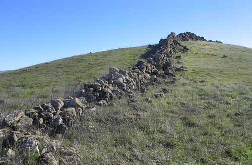
East Bay Mysterious Rock Walls are also known as the Berkeley Mystery Walls. These crude, stone walls are located in the San Francisco Bay Area in California. In places, they are up to a meter high and a meter wide; the walls run in sections anywhere from a few meters to over a half mile long. The rocks used to construct the East Bay Walls are a variety of sizes. Some are basketball-sized rocks, while others are large sandstone boulders weighing a ton or more. Parts of the wall seem to be just piles of rocks, but in other places it appears the walls were carefully constructed. The exact age of the walls is unknown, but they have an old appearance. Many of the formations have sunk far into the earth, and are often completely overgrown with different plants. The purpose of these walls is still unknown. Since the wall is not continuous and is composed of multiple sections, they could not have been used as a fence. They are not tall enough to have been used as defense mechanisms. The walls function is unknown as well as the constructors. The East Bay Walls are accessible in several area parks, including Ed R. Levin County Park in Santa Clara County and Mission Peak Regional Preserve in Alameda County. The walls are found in the east bay of San Francisco.

Ed Levin Rock Wall

The Real, True Story of the Mystery of the East Bay Walls | Bay Curious

East Bay Rock Walls and Alignments
There are many crude walls throughout the hills surrounding the San Francisco Bay Area. In places, they are up to a meter high and a meter wide and are built without mortar.The walls run in sections anywhere from a few meters to over a half mile long.

The rocks used to construct the walls are a variety of sizes. Some are basketball-sized rocks, while others are large sandstone boulders weighing a ton or more. Parts of the walls seem to be just piles of rocks, but in other places it appears the walls were carefully constructed.The exact age of the walls is unknown, but they have an old appearance.

America Unearthed: Ancient Ruins Discovered in California (S3, E7) | Full Episode | History

Berkeley Mystery Walls, Fremont, California
Neither Spanish settlers nor anyone since has been able to tell who built these strange California rock walls. There are remnants of ancient stone walls all over the East Bay, and no one knows how old they are, who built them, or why. Though people have been pondering the enigma of the Berkeley Mystery Walls for well over a hundred years, no conclusions have been reached, and despite wild speculation, no serious scholarly study has ever been undertaken.

Dikes and Sills
Visually, a dike looks like a natural wall of stone, sort of like a dam – or dike. A sill appears on a hillside or cliff face as a horizontal band of stone, like a window sill. Since both dikes and sills are originally of subterranean origin, some sort of regional uplift and/or erosion must have taken place to expose them at the surface. However, the East Bay Walls are definitely sandstone and full of shell fossils, so not volcanic by any stretch.

Mexican Rock Walls
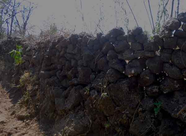
Mexican Rock Walls

Walls of Rock
I’m assuming many of the walls – there are miles of them in total around here – are put up by families, not someone making a solo effort. The work must be dangerous: to drop a heavy rock, or have it topple after it’s positioned, can easily be a bone-breaking event. Up on the trails, I’m conscious that a twisted ankle or a sprained knee would mean a painful hobble to get help, but having 120 pounds of lava fall on my foot would be a whole other problem.So, I tip my straw hat to the guys who can construct and maintain these things. The walls are often a guide to the route I need to take, and they also indicate the long, long heritage of land cultivation around here.

Grand Natural Wall Montana
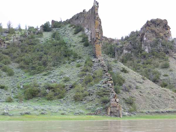
Grand Natural Wall in Montana
It is easy to see how these walls are formed and broken down by erosion by looking at the Grand Natural Wall on the Eagle Creek in Montana, the biggest of many igneous “dikes” that formed within sandstone cracks millions of years ago. This “wall-like” appearance is quite common along this stretch of the river. Millions of years ago, during active volcanic periods, dark molten material was forced into cracks in the sedimentary rock. Over time the molten material solidified and subsequent erosion of the surrounding softer rock exposed the dark igneous walls you see today.

Mystery Walls – Bison Weirs?
The Spanish settlers in the area reported that the walls were already there when they arrived, and when they asked the local Ohlone American Indians, they said the same thing. Some think ancient Chinese navigators would have built the walls, but there would have had to have been thousands of them here well before the Ohlone Indians and over 10,000 years ago. However, the walls were the only structure left, which would have been odd for a civilization that knew how to build from stone.

Stone walls at Ed Levin County Park
Arlene, a local hiker, asked me about the stone walls at Ed Levin County Park. She said she’s been to the park but hasn’t seen the walls. Perhaps she’s among the sane folks who avoid hiking to the heights behind Ed Levin’s Sandy Wool Lake — the summits require 2,000 feet of climb in 3.9 miles, most of it unshaded and wind-blasted. The insane, like yours truly, have enjoyed the benefits of gazing upon these these interesting piles of stone.

To reach the walls you have to hike to the Monument Peak summit, about a quarter mile from the intersection of the Monument Peak and Agua Caliente trails. Either trail is a major slog, but the Monument Peak Trail is a little bit easier.

Unravelling the Mystery Behind the East Bay Walls: Who Really Made Them and Why?
In the hills around East Bay and elsewhere near San Francisco, there is a series of stone walls that extend discontinuously for miles. The walls are about 3-4 feet high in most places and are not enclosed. There is also no record of them being built or who might have built them.

New England Is Crisscrossed With Thousands of Miles of Stone Walls
Notice how farmers in the 1800s and earlier built stone walls out of rock debris in their fields. A lidar map on this site shows how each field was enclosed by a small square or rectangle of these discarded rocks, never in long, unenclosed areas. They were built from the ground up, never buried like our Mysterious Walls. Usually the remains of a farmhouse can be found nearby to these New England walls. No buildings or foundations have been found near the walls in our hills.

Sheep Jumping Fence

Including this to show how even sheep can manage to get over a wall made of sticks about 4′ high. Why would anyone try to contain wild game like elk or deer or farm animals like cattle or sheep with low rock walls? I can see how maybe more modern people saw these already half built walls, and reengineered them for their own purposes, such as hiding behind when hunting.

The Character and Function of Ancient Chinese Walls and Fortifications
Early Chinese were building huge, wide walls for fortifications against enemies and against flood waters. They were very good at constructing such walls, and they worked as they expected. They were not randomly piled rocks. Our walls are up in mountains and none are near rivers that need diverting, which they wouldn’t work for anyway. And if the walls were built for defense, defense against whom?

More about Ancient and Medieval History in the South Bay Area

Temporary Policies and Guidelines Police Department Community Room

Police Logo Star

Novel Coronavirus (COVID-19) Temporary Policies and Guidelines Police Department Community Room

1275 North Milpitas Boulevard, Milpitas, CA 95035

Reservations: 408-586-2402 or vbejines@ci.milpitas.ca.gov

UPDATED: AUGUST 13, 2021

The Milpitas Police Department’s top priority is to ensure the safety of our guests. Please note that any meeting event in the Police Department Community Room is contingent upon current public health orders and City policy.

Vaccination Requirements

The City of Milpitas will not require guests to show proof of vaccination when entering the Police Department Community Room.

Masks and Face Coverings

Effective Thursday, July 29, 2021, the City of Milpitas requires all City employees and visitors to wear face coverings in indoor settings within City buildings, regardless of vaccination status. Masks will not be provided, and guests must bring their own when entering the building.

Room Capacity Limits

The City of Milpitas Police Department is limiting capacity to 35 guests max until further notice.

Food and Beverages

Food and beverages are not permitted, except for water.

Meeting and Time Limits

Only one reservation is permitted in the Police Department Community Room per day. Until further notice, reservations for the Community Room shall be on a first come, first serve basis. Reservations shall not be confirmed more than sixty (60) days in advance, and groups and individual applicants are limited to no more than two (2) reservations per calendar month.

***These guidelines supercede the Community Room additional guidelines dated July 2020. Public health orders are subject to change at any time, and reservations may be cancelled if the public health orders deem non-essential meetings unsafe.

*I have read and undertand the Novel Coronavirus updated policies and guidelines. I further understand that if my group does not abide by these rules, it may result in our meeting being immediately terminated and may result in not being able to use the room for future use.

On official document, applicant would sign and date. See Reservation contact info above.

Other halls in Milpitas.

FasTrak in Milpitas

FasTrak and COVID-19 – FAQs

What should drivers do? To drive in the FasTrak lane or not?

Cash is not being collected at Bay Area bridges due to COVID-19. Use FasTrak to pay your toll. If you do not have FasTrak, you will receive a bill in the mail for the amount of your toll. It is called a violation, but there are no penalties – just pay the toll by mail with a check or online. If you have FasTrak, this change does not apply to you.

The I-680 Sunol Express Lanes are designated lanes that can be used during heavy traffic to bypass congestion. Express lanes are usually located on the far-left side of select major freeway corridors (described below) and are indicated with white descriptive text on the pavement and electronic signage above the roadway.

How the heck do I drive along SR-237 now with the new FasTrak lane?

How to Order a Transponder and Use the SR 237 Express Lanes

Step 1: Order your transponder
Step 2: Set up your account
Step 3: Mount your transponder. Transponder mounting help.
Step 4: Use the Express lanes

About Express Lanes

An Express Lane is a portion of a High Occupancy Vehicle (HOV) lane, also known as a carpool or diamond lane, that has been converted to a toll lane in order to better manage congestion. VTA monitors its Express Lanes to maintain a minimum speed of 45 mph, based on federal requirement.

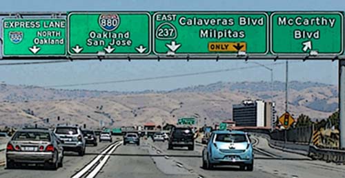
Express lanes are marked by large overhead signage, and smaller signs located in the median. The toll amount is posted on a changeable board within the large overhead sign.

VTA currently operates Express Lanes on State Route 237. Learn more about the planning and history of VTA’s Silicon Valley Express Lanes Program and the 237 Express Lanes project page.

How can I enter the FasTrak lane coming from Milpitas?

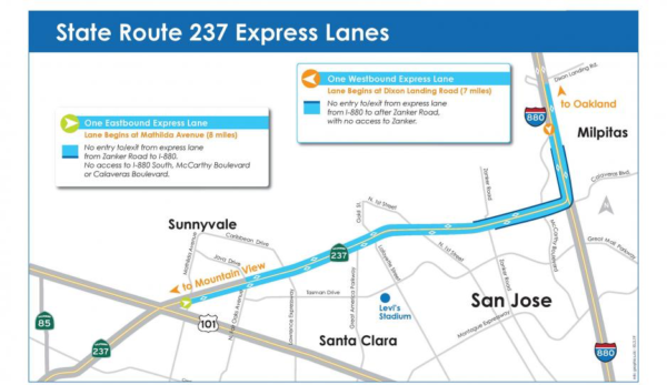
237 Express Lanes

  • Entering from Calaveras Blvd. westbound on SR237 will be a real pain, just as currently. You will not be able to get into the FasTrak lane until just slightly after Zanker, and it ends just before Lawrence. About half your commute will still be in heavy traffic. To avoid the congestion, you might try…
  • Drive north on Milpitas Blvd. to Dixon Landing Rd, and get on 880 south. Get in the HOV lane there as it swings over and onto 237.
  • Take Tasman. Turn right at Zanker. Enter 237 to right just after 237 overpass. Also good strategy for those heading north on 880 wishing to go west on 237.
  • Going eastbound on SR 237, there are double white lines west of Zanker Road prior to the 237-880 connector. Express lanes traffic wanting to access I-880 South, McCarthy Boulevard, or Calaveras Boulevard will have to exit the lane at Zanker Road.

FAQs about FasTrak

  • Questions about FasTrak? The FasTrak team is here to help! If you can’t find the information you’re looking for below, please contact us. Our Customer Service team wants you to get the most out of your FasTrak account.
  • FasTrak toll tags are also available to order online.

What hours and days is the Express Lanes operational?

  • SR 237 Express Lanes will now operate from 5:00 am – 8:00 pm weekdays, which is consistent with all other Bay Area Express Lane facilities. At all other times, the lane will be available to regular traffic.
  • Weekends everyone may drive in any lane they want to, with any number of people. FasTrak will not be in force.

What if I have a qualified clean air vehicle?

  • Clean air vehicles (CAVs) with valid clean air vehicle decals can travel toll free or at a discounted rate on Bay Area express lanes and state-owned bridges. In order to receive the correct discount, eligible clean air vehicles should use a FasTrak Flex or FasTrak CAV toll tag.
  • On 237, solo drivers in eligible CAVs will receive a 50% discount off the toll if they use a FasTrak CAV toll tag. The FasTrak CAV toll tag is the only transponder that will communicate the discounted toll rate to roadside toll equipment. Clean air vehicles with two or more people can travel toll free as a carpool, but must use a FasTrak Flex or FasTrak CAV toll tag.

Is it charging me each time it beeps?

  • No. It detects when you enter and leave the lane, and so charges you for total time spent in the FasTrak lane.

How do I know how much I am being charged?

  • Express lanes are free for qualifying carpoolers, vanpool, buses, and other toll-exempt vehicles.
  • For solo drivers with a FasTrak toll tag, the prices to drive to specific destinations will be posted on signs above the the express lane. The toll on VTA’s State Route 237 Express Lanes varies dynamically based on congestion. Minimum will be $0.30 and the maximum will be $8.00.
  • The actual toll deducted from your FasTrak deposit will depend on the total distance you travel in the express lane.
  • Tolls for solo drivers increase with congestion, and decrease with light traffic. But here is an example: the average toll paid by solo drivers in the I-680 Express Lane from Pleasanton to Milpitas in the morning commute period for January 2015 was $3.11, an average of $0.22 per mile over the 14 mile express lane length.

How do they know how many people I really have in my car?

  • Video cameras on the sign posts
  • Vigilant police
  • Setting you make on your tag for 1, 2, or 3+ people. Motorcyclists should leave their setting at 3+.

If I accidentally drive in the FasTrak lane without a transponder what happens?

  • You will get a bill based on your license plate registration. The price is listed on the overhead signs.

Bay Area FasTrak Facebook Page
This is the official Facebook page of Bay Area FasTrak. FasTrak is an electronic toll collection (ETC) system that allows you to prepay your tolls at all Bay Area toll bridges, eliminating the need to stop at the toll plaza. The system has three components: a toll tag, which is placed inside your vehicle; an overhead antenna, which reads the toll tag and collects the toll; and video cameras to identify toll evaders.hicles per hour than a cash lane.

As you pass through a toll lane, the toll tag is read, and your tolls are deducted from your prepaid toll balance. When you reach your replenishment threshold, your account is replenished automatically, if you opened your account with a credit card. If you opened your account as a cash/check account, then you are responsible for replenishing your account by making regular payments.

The FasTrak system tracks your usage and account balance. A monthly or quarterly statement itemizing your bridge use and account balance will be sent to you through the mail or emailed to you.

Ancient & Medieval History in the South Bay Area

You can find out more about ancient and medieval times right here in the South Bay Area. Learn about the mysterious rock wall formations, too.

Paleontological

Boy Paleontologists
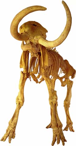
In the Irvington gravel pits, known as Bell Quarry, located off of Osgood Road from 1944 to 1960, the Boy Paleontologists of Hayward unearthed plant and animal fossils including mammoths, saber cats, horses, camels, and even rodents. A new species named Tetrameryx irvingtonensis, a four-pronged antelope, was the most significant find. Presently Freeway 680, between Washington Boulevard and Durham Road, covers this fossil field.

Children’s Natural History Museum
Including “Irvingtonian Fossils”, the “Boy Paleontologist” Room, “Bones of Vertebrates,” and “Environments through Time” exhibits. View the fossils from Irvington and Warm Springs District that provide clues for a changing landscape in the East Bay.
4074 Eggers Drive, Fremont, California
Open Tues and Thurs 2-5, first and third Saturdays (1-5).

Fossils of Fremont
Geology maps help to show where fossils may be located along the Mission Fault line.

Fossil treasure trove discovered at Silicon Valley construction site
The discoveries are revealing what Silicon Valley looked like 20 million years ago during the Miocene Epoch, when the ocean extended as far inland as Bakersfield. Since 2011, when work on the project began, crews have found nine whale skulls, to be exact. They have inventoried 529 types of fossils altogether. Of those, 168 are vertebrates, such as sharks; 267 are invertebrates, such as scallops — some as big as dinner plates. Thirty-nine 39 are plants, such as fossilized pine cones; and 55 are other ancient items, from animal tracks to burrows.

Columbian Mammoth

Mammoth Discovered in San Jose
On Saturday, July 9, 2011, Roger Castillo, a San Jose truck mechanic, was walking his dog along a levee next to the Guadalupe River, just north of West Trimble Road and the Mineta San Jose Airport. The bones may belong to a Columbian mammoth, Mammuthus columbi, a species known to have lived in the San Francisco Bay Area during the Late Pleistocene.

Trove of ancient marine fossils surprises Bay Area dam builders
Crews had no clue when work started on a Bay Area dam in 2011 that they would stumble onto a trove of marine fossils many millions of years old. Hundreds of specimens have been found at the Calaveras Dam site near Milpitas, Calif. Among the 529 specimens inventoried are scallops as big as dinner plates, a hippo-like mammal called a Desmostylus, megalodon sharks, and whales with and without teeth. Most of the fossils are believed to be about 20 million years old.

Ancient History

Rosicrucian Egyptian Museum & Planetarium
Temporarily Closed. While not exactly Milpitas history, you’ve never seen so many mummies and ancient artifacts in one place! Located in San Jose.

Medieval

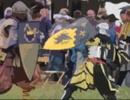
Medieval-SCASociety for Creative Anachronism
The International Headquarters of this organization is in Milpitas! This is a link to the first page of their Heraldry section. Want a Coat of Arms?

The Principality of The Mists
Greater San Francisco Bay Area and Monterey Area SCA groups.

Roads & Highways

Find out about road construction plans and delays. Learn what government agencies control these highways. And to relax, enjoy these scenic drives starting in Milpitas, and wandering through our hillsides on backroads.

What is Milpitas known for?
Milpitas is often called the “Crossroads of Silicon Valley” with most of its 13.63 square miles of land situated between two major freeways (I-880 and I-680), State Route 237, and a County expressway.

How far is Milpitas from San Francisco?
The distance between Milpitas and San Francisco is 37 miles. The road distance is 45.9 miles, unless you have a boat to sail between Alviso and San Francisco.

Construction
Governmental Agencies
Scenic Drives

Construction

Calaveras Overpass
The Calaveras Overpass is built to meet the present and growing traffic loads of a progressive city. [They thought!]

Montague Expressway Widening
This project widened Montague Expressway to provide for eight through lanes (three through plus one HOV lane in each direction), with bike use shoulders and improved pedestrian sidewalks from Falcon Drive to Pecten Court (approximately 0.8 miles) including replacement of the double-box culvert crossing of Berryessa Creek with a bridge structure.


VTA Montague Expressway Pedestrian Overcrossing
An incredible project RockViewVideo filmed in Milpitas to chronicle the lift & placement of a huge pedestrian overcrossing above Montague Expressway adjacent to the Milpitas BART Station, July 10-12, 2020.

Transportation Information
As a prominent gateway to the Silicon Valley, the City of Milpitas’ Traffic Engineering section has an integral role in maintaining the City’s economic vitality and creating safe and livable neighborhoods that are pedestrian and multi-modal friendly.

Filing a claim against Caltrans
Did you get a nail in your tire in a highway construction zone? Here’s information and the form for filing a claim.

Governmental Agencies

CalTrans
California Department of Transportations, District 4 (includes Santa Clara County). Lots of local information and pictures about Bay Area Bridges.

Metropolitan Transportation Commission
Regional planning group for our highways here in Silicon Valley and around the Bay.

Scenic Drives

Bay Area Backroads
Go “day tripping” to places near and far. KRON TV offers hundreds of ideas in the South Bay Area and further away.


Calaveras Road to Sunol
Calaveras Road varies from 2 lanes in Milpitas and the 84/680 end in Fremont down to 1 lane in the middle. The south half was recently repaved from Milpitas to the Alameda County line, about 2/3 of the entire ride.

Calaveras – Sierra Rd Loop
Scenic drive in the snowy mountains east of Milpitas and San Jose, California.

California Roadside Rest Areas
Plan your rest stops in rural areas.

Main Street History Tour
Joann Souza narrates a tour of Main Street telling about the historic buildings and sites along the way.

Mt. Hamilton Road
Take this mountain road between Alum Rock and Patterson. Do fill up your thirsty steed because if you decide to continue east down the other side of the mountain, it will be another 70 miles to the next gas station. Very windy and steep. Not for the faint-hearted.


Santa Cruz Mountains Roads
A lovely drive is the one through the redwoods from Woodside, over to the coast, down to Santa Cruz, and back over Rt. 9 through Boulder Creek and Big Basin State Park to Saratoga.